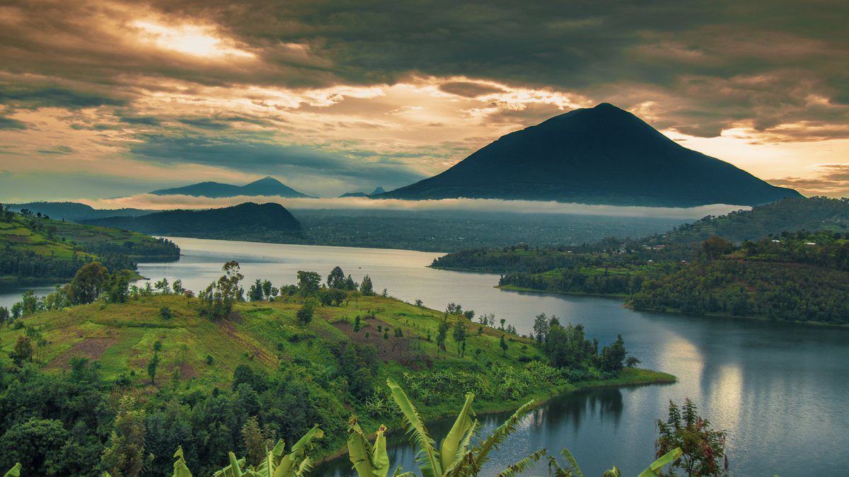
Mount Muhabura
Mount Muhavura, also known as Mount Muhabura, is one of eight Virunga mountains that stretch across Uganda, Rwanda, and the Democratic Republic of the Congo. It is the third-highest volcano of the eight Virunga massifs and is located in Mgahinga National Park in southwestern Uganda. Mount Muhavura, Mount Sabinyo, and Mount Gahinga comprise the three mountains in Mgahinga National Park. Mount Muhavura is an extinct volcano located in Mgahinga National Park in Uganda and Volcanoes National Park in Rwanda, with Uganda owning the majority of the mountain. Muhabura, also known as Muhavura means “the guide” in Kinyarwanda, and it is thought that the mountain got its name because it is the highest of the three mountains in Mgahinga National Park and can be seen from most parts of Rwanda.

Hiking this mountain is one of the most rewarding experiences because it is one of the highest Virunga volcanoes; conquering it is an accomplishment, but it also provides hikers with great views of the East African region, nature expeditions, and, if you are lucky, sightings of wildlife roaming around their habitat, though this is quite rare.
Mountain Muhabura is more difficult to climb than Mount Karisimbi because it is steeper, but it can be hiked in a single day. It is the most interesting of the Virungas because tourists are rewarded with breathtaking views of the other Volcanoes and the Twin Lakes of Ruhondo and Burera while at the Peak.
Another intriguing feature of Mount Muhabura is that its Crater Lake is located near its summit, and the vegetation is always drier than in other parts of the Volcanoes National Park. Muhabura is linked to Mount Gahinga by a wide saddle in the west, which has a 40-meter-high Crater Lake at its summit.
Hiking Mount Muhabura volcano in Uganda
To hike mount Muhavura, travelers can book permits in advance, though this is not always necessary, or even on the day of the hike. Unlike Mount Sabinyo, which can only be reached from the Ugandan side, Mount Muhabura can be reached from both the Ugandan and Rwandan sides. Hiking Mount Muhabura usually takes 5-6 hours depending on your pace, but it also requires a certain level of fitness.
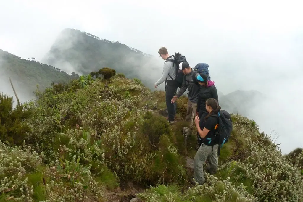
The hiking process is the same in both countries, and hiking through Mount Muhabura usually takes a full day. It usually begins with tourists determining whether they have the necessary hiking equipment and supplies, which include a packed lunch, snacks, drinking water, hiking boots, long trousers, long-sleeved shirts, and a walking stick to assist them on the slopes, among other things. Tourists must then report to the Park headquarters at the Ntebeko visitor’s center by 7:00 a.m. for a pre-hiking briefing. This briefing includes an explanation of the Mountain’s formation and history, hiking guidelines, tips on how to deal with injuries, and what to expect as you climb to higher elevations.
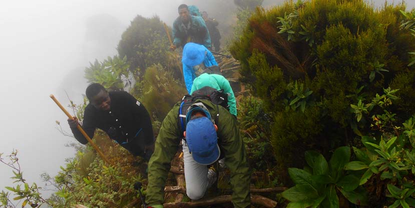
Following the briefing, tourists are driven to the trailhead at the Volcano’s base. The hike is led by armed rangers to protect tourists from wild animals such as elephants and buffaloes, which are frightened by shooting in the air. Before reaching the summit, the hike is divided into two stops, each with a hut.
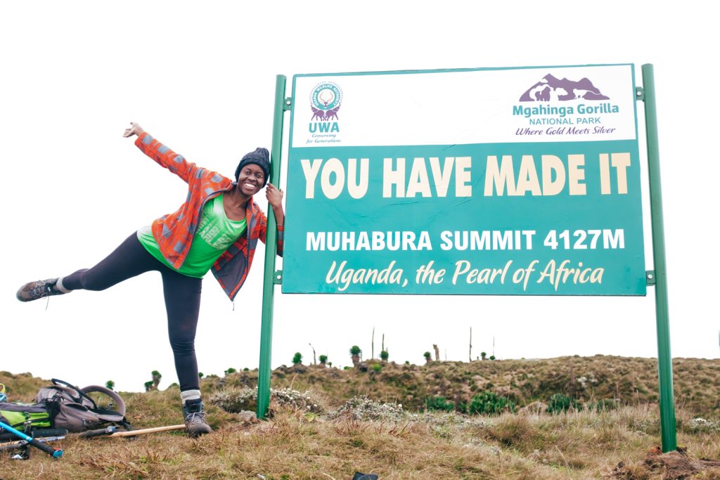
The first stop is 3116m /10223ft above sea level, followed by 3855m/12648 ft above sea level. The climb’s highest point is 4,127m/13,450ft above sea level. You will be among the first to reach the summit because some hikers stop at the first hut and others at the second.
The tourists will encounter many animals such as hyenas, golden monkeys, mountain gorillas, duikers, monkeys, and several bird species while hiking on Mountain Muhabura. At one point, they will stop for a picnic lunch and then proceed to the summit passing through various vegetation covers and rocks. Mountain Muhabura’s summit offers breathtaking views of the surrounding scenery, Virunga volcanoes such as Sabyinyo, Gahinga, Bisoke, Nyiragongo, and Karisimbi, and views of various lakes, including the small one at the summit, Lake Bunyonyi in Uganda, and Burera and Ruhondo in Rwanda, among others.
The summit is cold and misty, but the climb may tempt you to swim in Crater Lake. After experiencing the peak, you will proceed down the slope, which is a little easier than climbing up because the lower you go, the more oxygen there is, resulting in less altitude sickness, and the advantage of gravity makes going down a little easier.
Mountain Muhabura hikes are frequently combined with other activities such as mountain gorilla trekking in Mgahinga National Park or volcanoes, golden monkey trekking in Uganda or Rwanda, birding, and cultural visits. Nature walks in Mgahinga are also often combined with hiking because this is a very hilly area and hiking is difficult to avoid.
During your visit to Mgahinga Gorilla National Park, you can always visit several amazing places. These are always guided nature walks with armed escorts who are provided to walk alongside you during your nature walk, so you will visit and see the scenery as well as the various tourist attractions in the area with the help of your guide.
Best time to Hike Mount Muhavura
Mountain Muhabura can be hiked at any time of year, but some months are better than others, and these are the dry months. Hikers should hike Mountain Muhabura during the dry season, which runs from June to September and December to February, because rainfall is minimal or non-existent during these months, leaving the trekking trails dry, the vegetation thin, and the roads leading to the park passable.
Hikers can still hike Mountain Muhabura during the rainy season, which lasts from March to May and October to November, but they should be aware that there is a lot of rain, the trekking trails are muddy and slippery, which slows hikers down, the vegetation in the park is tall, which obscures views of the animals on the mountain’s slopes, and the roads leading to the mountain are impassable. Hikers will only benefit from significant discounts on lodging.
How much does a hiking permit for Mount Muhabura cost?
Hiking Mount Muhabura requires a hiking permit, which can be obtained from the park headquarters for each person at USD 80 for foreign non-residents, USD 70 for foreign residents, and UGX 50,000 for East African residents. Mountain Muhabura permits can be purchased in advance, but they can also be purchased at the park offices on the day of the hike.
More to that, you will also have to pay park entrance fees for Mgahinga national park which cost USD 30 for foreign residents, and UGX 20,000 for East African residents per day.
What to carry for your Mountain Hiking adventure
While you are packing, use this handy day hiking checklist to make sure you don’t forget anything important. Hiking backpack, Weather-appropriate clothing (thick moisture-wicking and layers), Hiking boots or shoes, Plenty of energy-giving food, Plenty of water, Navigation tools such as a map and compass, First-aid kit, and if possible, a Knife or multi-tool.
Aside from the items listed above, don’t forget to bring a good camera, binoculars, and fresh batteries. Binoculars will be required to get a better view of the distant volcanoes and other landmarks. A good camera will assist you in taking good photos to show your friends and family.
This checklist is designed to be exhaustive and is intended for day hikes in the backcountry where self-sufficiency is critical to your well-being. It contains far more items than you’re likely to require for short hikes in or near developed areas, such as city parks, though you can tailor it to your needs for these excursions.
How to get to Mt. Muhavura for your hike
Mount Muhavura is accessible by car from both Uganda and Rwanda. It will take 8 hours to drive from Kampala, Uganda, to Kisoro via Kabale (close to 510 Kilometers). Once in Kisoro, you can take a taxi or a local motorcycle to the Mgahinga National Park headquarters. If you are taking public transportation or a motorcycle taxi (Boda Boda), please keep the phone numbers and names of the divers/riders so that you can contact them once you have finished climbing the mountain to transport you back. There are few vehicles and motorcycles on the route between Mgahinga National Park offices and Kisoro town, especially late at night.
Those who drive themselves should be very aware of their surroundings. Keep an eye out for signposts directing you to the park as you pass through nearby trading centers or small towns. Make certain that the car you hire has GPS. Those climbing Mount Muhabura Volcano from Rwanda simply travel 3 hours by road from Kigali to the Volcanoes National Park. If your journey begins in Kigali, Rwanda, you must leave by 5 a.m. to arrive at the park in time for the briefing.
It is also possible to arrange a chartered flight from Entebbe, Uganda, or Kigali, Rwanda, to the national parks’ nearest airstrips. Aerolink operates daily flights from Entebbe to Kisoro Airfield in Uganda. Entebbe to Kisoro flights takes one hour. A driver can then meet you at the Kisoro Airstrip and drive you to the park.
