DISCOVER UGANDA
Hiking Trails on Rwenzori Mountains
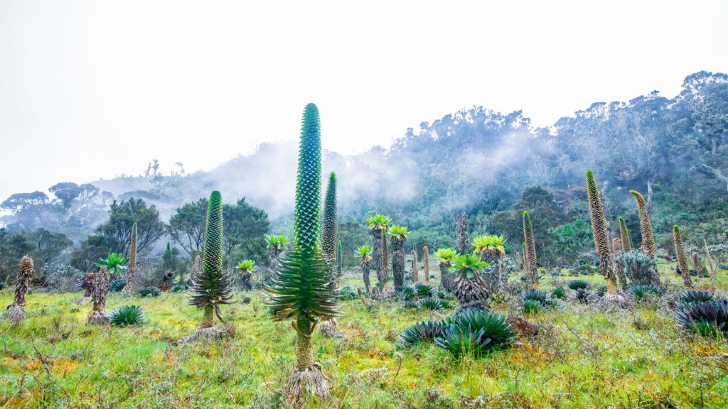
The Rwenzori Mountain National Park is one of Africa’s most beautiful and unique trekking destinations, taking you up through the 6 different vegetation zones at 680-1800 meters, Afromontane Forest zone at 1800m-2600 meters, Bamboo Forest Zone at 2600-2900 meters, heather Zone at 2900-4000 meters, Afro-alpine moorland zones at 4000-4500 meters, and rocky/glacier zone standing between 4500-5109 meters above sea level. The Rwenzori Mountains National Park covers approximately 100,000 ha in Southwestern Uganda and contains the majority of the Rwenzori mountain ranges, including Africa’s third-highest peak (Margherita at 5,109 m).
The Rwenzori Mountains are a UNESCO World Heritage Site where tourists may see nature at its best. With stunning panoramas, the plant life extends from deep tropical rainforest to bamboo forests, montane cloud forests, and alpine flora.
Hiking Trails on Rwenzori Mountains
The Rwenzori Mountains in Uganda are Africa’s third highest peak. Every year, many people from all over the world travel to Uganda to trek to the top of this mountain. Many tree and plant types, as well as flowers, may be found on the mountain. If you appreciate beautiful mountain scenery and trekking but lack expert mountaineering abilities, there are two pathways in the area that will provide you with a great Rwenzori experience without the daunting difficulty of conquering these mountains. There is something special about visiting the Rwenzori Mountains, and these two routes will provide you with all of the magnificent splendor of the region.
Central Circuit at Rwenzori Mountains
The Rwenzori Mountains’ core circuit is the oldest and most popular path to the beautiful Margherita Peak on Mountain Rwenzori. The indigenous Bakonjo people that live surrounding the mountain maintain and administer it. The main reason it was deemed an appropriate path to the top is that, unlike other routes, the central circuit route is easier and less strenuous for inexperienced hikers.
It also has a lot to offer hikers, such as excellent views of all the other gateway peaks, such as Baker, Speke, and Stanley, as well as flora landscape, bird species, animal species, and primates, among other things. The ascent and descent of the mountain along this hiking trail is notable since hikers can transfer along several pathways, allowing hikers to explore and discover more of the mountain. Lodging along this route is provided in the form of wooden cottages at specific stations for all walkers.
Kilembe Trail
The Kilembe track is another alternative for hikers, albeit it is more difficult to reach Margherita Peak than the Central Circuit route. It is a difficult and challenging hike, thus it is not recommended for inexperienced hikers. It is challenging and quite steep, requiring trekkers to expend a lot of energy throughout the walk. It is a very beautiful trail to climb because of its remarkable beauty, and it allows hikers to explore more on the many routes they take as they ascend and descend the mountain.
The many hiking trails on the Rwenzori Mountains allow you to see the changing environment, which includes wooded areas, rocky areas, and boogy flora, as well as the pure countryside. Because of the difficult experience, this should be your path to Margherita Peak for all keen hikers. At various points along the mountain, you will sleep in huts.
Hiking Tours to Rwenzori Mountains
When is the Best time to visit the Rwenzori Mountains?
The Rwenzori Mountains are accessible all year. The primary tourist seasons are generally from July to October, followed by December to February. These months correspond to Uganda’s dry season. Many visitors travel from June to October, as well as in December, for gorilla and chimp trekking, which they prefer to combine with a Rwenzori mountain hiking safari tour. The Rwenzori mountains are best climbed during the hottest and driest months.
The biggest concern is safety, since the hazards of climbing rise dramatically when the weather is bad. Rain, mud, snow, ice, and cold may be quite taxing on the body, especially if you are a first-time climber. There are two wet seasons: the long and brief rainy seasons. The lengthy rainy season starts in March and lasts until May. During the month of November, there is a brief rainy season. Please keep in mind that weather is unpredictable, thus these times will fluctuate from year to year. Rain can fall early or late, and it can be heavy or light.
When should I climb the Rwenzori Mountains?
July, August, and September are the most popular months for most individuals. The next favorable months are October, January, and February. These six months, including December, are considered the peak season for trekking expeditions on the Rwenzori. December, March, and June are shoulder season months. Finally, rain falls in April, May, and November. These three months are considered Rwenzori’s low season, with many trip companies offering discounts.
Climbing the Rwenzori Mountains During the High Season.
The best part about climbing now is that you can stay dry the entire time. Yes, it can rain at any time of year, especially in the rainforest and moorlands, but the precipitation is normally light and sporadic. You will be more comfortable and have a more pleasurable climb to the mountain peak if you keep dry. In addition, during the dry season, the vistas are enhanced by bright and sunny skies. The negative is that there are many climbers on the paths, which might detract from the sensation of being on a large, solitary mountain. Unsurprisingly, most people prefer to climb during the dry season since the prospect of pleasant weather outweighs any concerns they may have about encountering other people on the mountain.
Climbing the Rwenzori Mountains During the Low Season.
Some visitors choose to climb the Rwenzori Mountains in Uganda during the low season because they want to have the mountain to themselves. The mountain is quite vacant, and you may be the sole group at a campground. This is peaceful, and many people want isolation when they walk outside. Second, while it does rain often during the low season, it usually showers in the afternoon. With Rwenzori’s hiking schedule, most of the trekking can be done in the mornings, minimizing time spent on the path while it rains.
What wildlife attractions can I see when climbing the Rwenzori Mountains?
The vegetation zones are home to 70 animal species and 177 bird species. Elephants, chimps, Rwenzori otters, and leopards are among the animals. Despite their presence, they are rarely observed due to the deep jungle. Primate species such as colobus (Angola and black-and-white versions are thought to exist), blue monkeys, and tiny antelope such as bushbucks are easier to see, as are uncommon reptiles such as the three-horned chameleon.
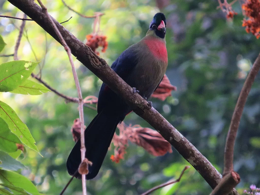
Some of the bird species here are Albertine Rift endemics, making the Rwenzoris an Important Birding Area (IBA). The greatest diversity is found in the montane forest where you may see the Rwenzori Turaco, Barred Long-tailed Cuckoo, Long-eared Owl, Handsome Francolin, Cinnamon-chested Bee-eater, Archers’ Robin-chat, White-starred Robin, Rwenzori Batis, Montane Sooty Boubou, Lagden’s Bush Shrike, Slender-billed Starling, Blue-headed Sunbird, Golden-winged Sunbird, Strange Weaver and several varieties of Barbets, Greenbuls, Apalises, IIladopsis, Flycatchers and Crimson wings.
WHAT TO KNOW BEFORE HIKING RWENZORI
What type of Mountain is Rwenzori?
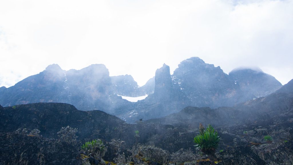
The Rwenzori Mountains are a stiff, stony mountain range formed by tectonic activity responsible for the formation of the western rift valley. The Rwenzori Mountains have an ancient basement of diverse rocks that were extruded from adjacent plains by the time the western rift valley was formed.
Is there internet or Wi-Fi on Mount Rwenzori?
At the moment there are no internet services on the mountain, so hikers can only access internet once they reach the base of the mountain.
What accommodation options are found on Rwenzori Mountains?
During a Rwenzori hiking trip, lodging is practical yet pleasant. After a long journey, the creature amenities of a cheap lodge will feel lavish. The wooden shelters in the mountains are built to keep the worst of the weather out and to give room for storing items needed on various portions of the trek. The Rwenzori Mountains National Park’s foothills are home to a variety of cozy resorts, hostels, and campgrounds that provide for suitable headquarters for your explorations.
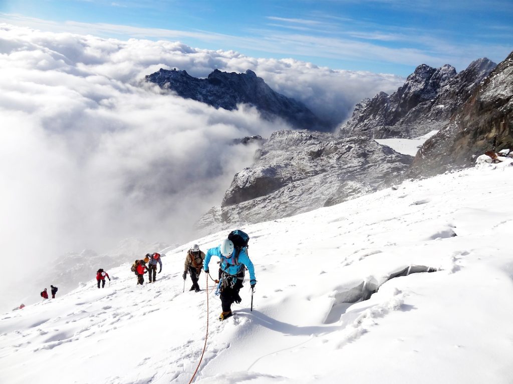
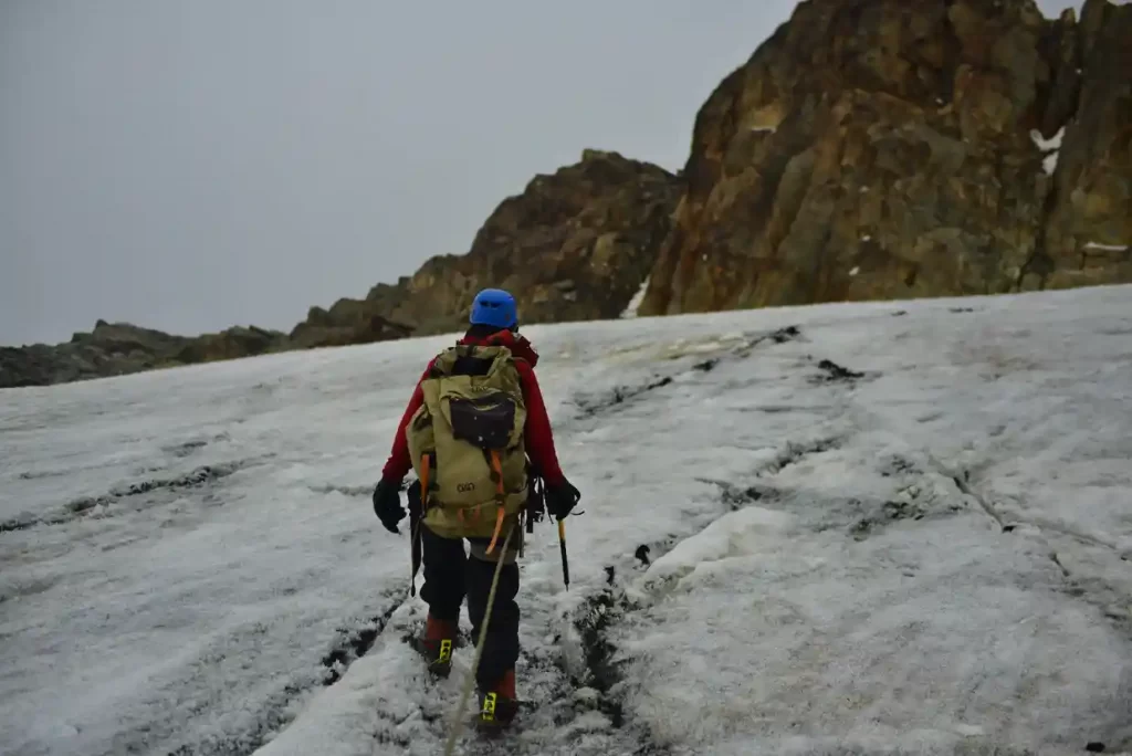
Is it difficult to hike Mount Rwenzori?
The Rwenzori Mountains are one of the world’s most thrilling and difficult mountain ranges to travel. A unique and enchanting realm of 996 square kilometers of fantasy vegetation, lakes, rocky outcrops, cliffs, towering glaciers, and snow-capped summits exists.
Do I need a guide to hike Mount Rwenzori?
Yes, if you are planning to hike Mount Rwenzori, you will definitely need the profession expertise of a Rwenzori guide who is well versed with most of the trails on the mountain.
Will altitude sickness be a concern when hiking Rwenzori Mountains?
If you suffer from altitude sickness, that should be a concern, but it should not deter you from taking on the task. Check up with your doctor and make sure you receive prescription altitude sickness medication.
Should I carry medicine for altitude sickness on Rwenzori Mountains?
Yes, if you suffer from altitude sickness, make sure to get prescribed medication from your doctor before embarking on your hiking safari to Rwenzori Mountains in Uganda.
Why are the Rwenzori Mountains referred to as Mountains of the Moon?
Mount Rwenzori, also known as the Mountains of the Moon, was named by Greek explorers as they sought to identify the source of the Nile. Diogenes, a merchant, said that the Nile’s source was a group of mountains known to the locals as the Mountains of the Moon because of their snow-capped whiteness. About AD 150, the Alexandrine geographer Ptolemy dubbed the Rwenzoris the “Mountains of the Moon.”
Why is Rwenzori Mountains snow-capped?
The Rwenzori Mountains are 5,109 meters high (16,761 feet). These mountains, along with Mount Kenya and Mount Kilimanjaro, are Africa’s only perennially snowcapped peaks on the equator. Yet, the phrase “permanently” appears in quotation marks since global warming is steadily melting the Rwenzori Mountain glaciers. The snow-capped form of the Rwenzori Mountains is caused by decreasing air pressure increasing elevation. Because heated air expands and cools, rising air expands and cools. This procedure increases the quantity of moisture in the air. Greater moisture equals more rainfall, and more snow is formed at the very top of a mountain.
How long does it take to hike Rwenzori Mountains?
Low altitude treks generally last 2-4 days and do not exceed 4,000 meters. High altitude climbs span 4-12 days and take you to peaks over 4,000 meters.
How much luggage should I carry on a hike on Rwenzori Mountains?
You will need two bags for your Mount Rwenzori challenge hike: a backpack to carry your daily supplies and a duffel to contain the 15 kilos (33 pounds) that your own porter will carry for you. A duffel bag is recommended since it is easier for the porter to handle while carrying other bags.
What is the highest peak on Rwenzori Mountains?
Margherita Peak, at 5,109 meters, is the highest point on Mount Stanley in the Rwenzori Mountains and Africa’s third-highest mountain. It is the gem in the crown of the high-altitude Rwenzori circuit, which begins in the lush woods of the foothills before climbing well above the sky to Margherita’s frigid peak.
How to get to the Rwenzori Mountains in Uganda?
If you take the road through Fort Portal, the travel from Kampala to Kasese will take around 7 and a half hours. While visiting the Rwenzori Mountains, it is suggested that visitors utilize 4×4 vehicles.
The city of Kasese is the closest built-up location to the Rwenzori Mountains. Kasese is easily accessible by air from Entebbe, with daily flights lasting slightly more than an hour. The road trip from Entebbe/Kampala through Fort Portal, on the other hand, takes 6-8 hours.
You may also fly from Entebbe to Kasese. The planes leave Entebbe at 7 a.m. and 12:30 p.m. every day, perfectly aligning with trek departures. Every day at 10:45 a.m. and 2:45 p.m., the return flight departs Kasese. The flight lasts roughly one hour.
