When Is the Best Time to Climb Mount Rwenzori?

Mount Speke

Mount Speke is the second-highest peak of the Rwenzori ranges located in the Rwenzori Mountains National Park. Mount Speke, Mount Baker, and Mount Stanley create a triangle that encircles the upper Bujuku Valley. Mount Speke is located 3.55 kilometers (2.21 miles) to the south-southwest. These mountains are located in a region known as The Mountains of the Moon. All of the mountains in this range have several craggy peaks. Mount Speke’s summits include Vittorio Emanuele (4,890 metres (16,040 feet), Ensonga (4,865 metres (15,961 feet), Johnston (4,834 metres (15,860 feet), and Trident 4,572 metres (15,000 feet).

10-Days Mountain Rwenzori Hiking

Despite the fact that the names were acquired from an Italian royal line, they had to be accepted by the administration of the British Protectorate of Uganda, which administered the region at the time. When European explorers first visited the region in search of the source of the great Nile, this peak was named after John Speke. Speke sketched the source of the White Nile in 1862, despite never hiking this summit. All of the mountains in this region are named after connected explorers who arrived in Africa during the early days of colonialism. Mount Speke is pierced by multiple water streams and rivers as a result of the heavy rainfall it receives, and its flora appears dense.

Trips to Inspire

10 Days Rwenzori Hike

12 Days Rwenzori & Primates

6 Days Rwenzori Hike

How to Get to Mount Speke

Day 1: MIHUNGA GATE (1651 meters above sea level) – NYABITABA CAMP (2651m asl.)

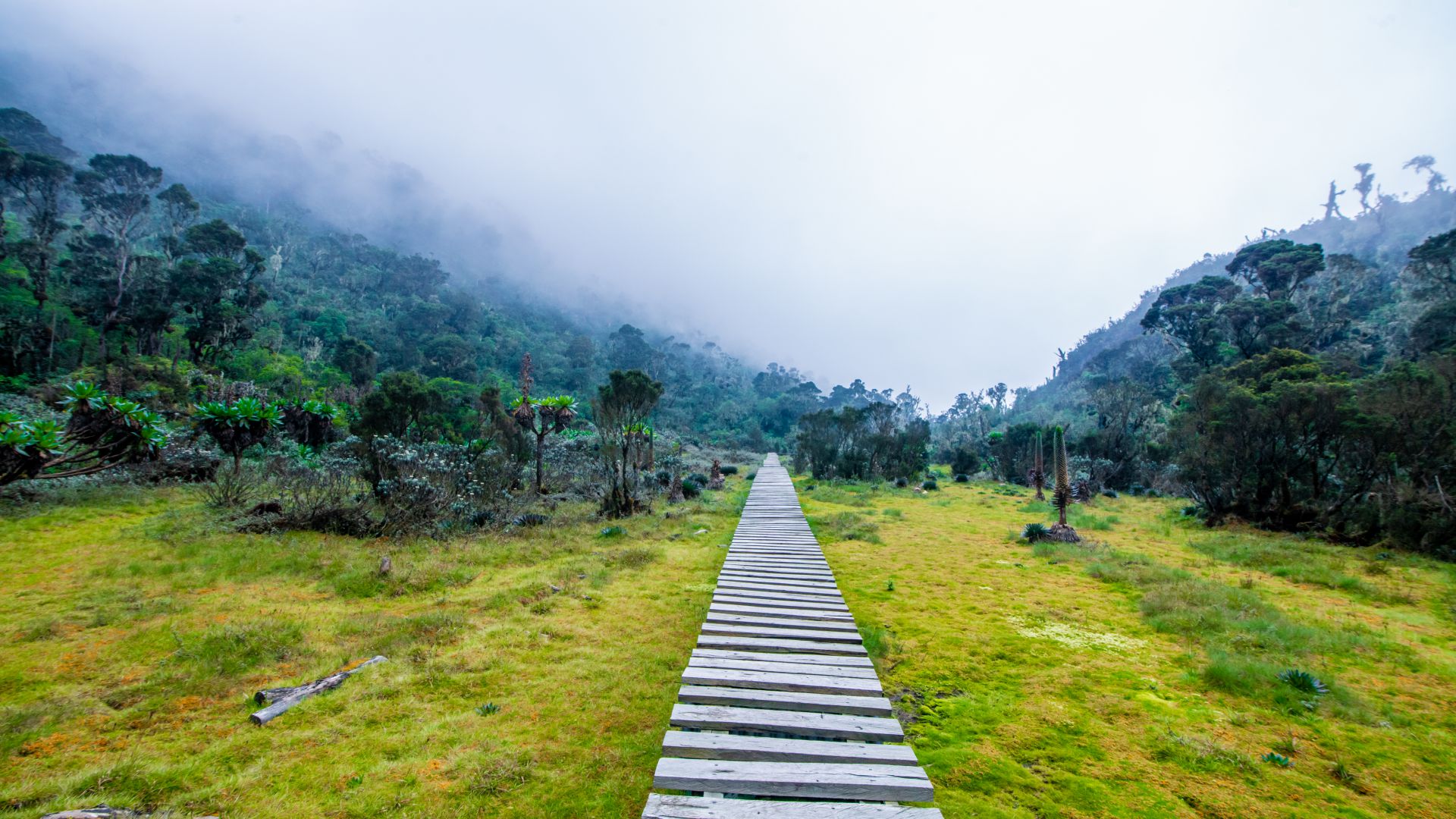
The hiking expedition with Mount Speke summit begins at the Park’s gate in Mihunga and follows the Central circuit trail. As you near the park gate at the end of the drive to the gate, you’re greeted with refreshing air descending from the mountain, which energizes you for the journey ahead. The trail begins by traversing through farmland to the park boundary. It then follows a dense forest along River Mubuku, crossing its offshoot the Mahoma River, before beginning a lengthy, steep climb up onto a large ridge to reach Nyabitaba camp.

Mountain Rwenzori peaks and gorilla trekking

You may hear chimps and see black and white colobus, blue monkeys, and the brightly colored Rwenzori turaco during this portion of the tour.

The hike takes about 6 to 7 hours on average.

Day 2: NYABITABA – JOHN MATTE CAMP DAY 2 (3505m asl.)

Follow the trail down through the forest from Nyabitaba to the Kurt Shafer Bridge, which is right below the junction of the Mubuku and Bujuku rivers. Traverse a long and laborious stretch of slick moss-covered rock while traversing through the bamboo grove. Mount Stanley and Speke are seen from the Nyamuleju rock shelter before entering the zone of gigantic heather, lobelia, and groundsel. After a long journey across the muck, you will arrive at John Matte Hut. The Central Circuit Trail’s longest day is today. Dinner and sleeping at the John Matte cabin.

The hike takes about 7 to 8 hours on average.

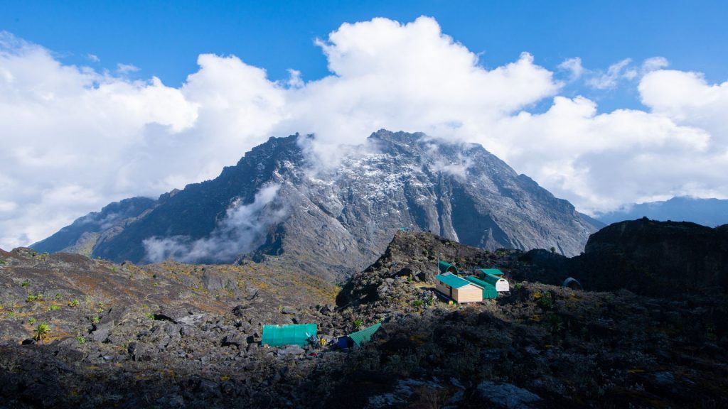
Day 3: JOHN MATTE – BUJUKU CAMP – DAY 3 (3962m asl.)

View from atop mountain rwenzori

The trail descends from John Matte Hut to bridge the Bujuku River and enters the Lower Bigo Bog, which is home to huge lobelias. The bog is finally crossed by leaping from tussock to tussock. The upper Bigo bog inevitably leads to Bujuku Lake, with views of Mount Baker and Mount Stanley to the south and west. Bujuku Hut is located in a ravine below Stuhlmann’s Pass, under the shadow of Mt Baker and Mount Speke. This camp is ideal for acclimatization for guests planning to ascend Mt Stanley and Mount Speke.

Bujuku hut for dinner and nights.

The hike takes about 4 to 5 hours on average.

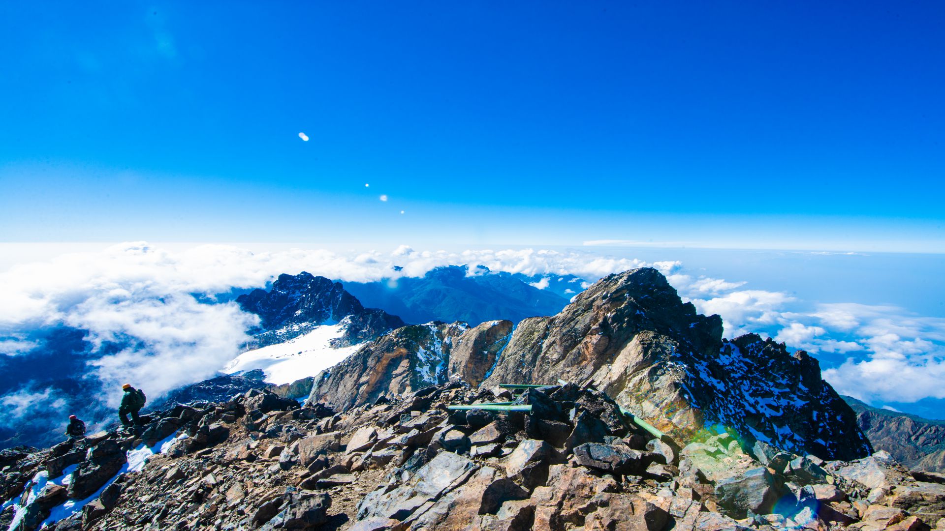
Day 4: BUJUKU – MT. SPEKE (4890M asl.) – BUJUKU – JOHN MAATE

Begin the walk to Vitorio Emanuele summit early in the morning across Stuhlmann’s Pass (4192m asl.) and beautiful views of the Virunga National Park in the Democratic Republic of the Congo. The climb to the summit takes 4 to 5 hours. Prepare to descend from Vittorio Emanuele to Bujuku camp with views of the Bujuku valley and lake, Margherita and Albert peaks on Mt Stanley, and Mt. Baker returning to Bujuku and continue to John Maate Camp for an overnight stay.

The descent takes between 3 and 4 hours on average.

Day 5: JOHN MAATE – NYABITABA – NYAKALENGIJA (Day 5) (1615m asl.)

The trail traverses the Kichuchu cliffs below Guy Yeoman. The muddy trail beyond Kichuchu crosses River Mubuku twice through a bamboo forest before ascending to Nyabitaba to finish the round. Continue the descent to Nyabitaba Camp and finish your trip by the evening to Mihunga gate, where you will spend the night at your hotel in Kasese.

The descent takes between 7 and 8 hours.

Other Mountains On The Rwenzoris

Mount Baker

Mount Baker is Africa’s sixth highest mountain, with its highest point, Edward Peak, standing at 4844 meters (15892ft). Mount Stanley is so close. The upper Bujuku valley is formed by the triangle formed by Mount Stanley, Mount Baker, and Mount Speke.
The mountain baker was called after Sir Samuel Baker, the first European to see Lake Albert, which is located northeast of Mount Rwenzori.
Mount Baker’s summit offers views of the twin peaks, the Margherita glacier, Mount Speke, and the stunning beauty of the Rwenzori Mountains.

Mount Gessi

Mt Gessi and Mt Emin are located in the Rwenzori Mountains to the north of the Mount Stanley, Speke, and Baker triangle. It was named after the source of the Nile’s Italian explorer Romulo Gessi. The mountain also includes twin peaks, Iolanda (15,470 ft.) and Bottego (15,470 ft). (15,418 ft.). It is close to Mount Emin, which is separated by by a tiny valley.
The trek to the top begins in the Mugusu valley and proceeds through groundsel forests to Roccato pass, then through heavy brush and slabs to the ridge between the peaks. These summits were formerly covered with glaciers, which melted away.

Mount Emin

Mount Emin, which stands at 15742 feet in the Rwenzori Mountains, was named after central African explorer Mohammed Emin Pasha. Despite the lack of snow, the difficult mountain with narrow and rocky ridges is regarded the fourth of the Rwenzori ranges and the sixth in Africa.
The mountain contains two peaks, Umberto (1574ft) and Kraepelin (15720ft), both of which are located between the borders of Uganda and DR Congo, making access easier from the Congo side. Climbing this peak in the Rwenzori Mountains National Park often begins from the south west of the Ridge and is easily accessible from the Mugusu Valley, which extends into Congo.

Mount Stanley

Mount Stanley is the highest peak of the Rwenzori Mountains. These Mountain ranges border Uganda and the Democratic Republic of the Congo. This beautiful mountain rises through jungle and strange bogs to a series of jagged peaks ringed by Africa’s biggest concentration of glaciers. Mount Stanley is a fault block mountain in the African Rift System that rises between two rifts. They are composed of gneiss and quartzite and were produced within the last 10 million years. The mountains are almost always shrouded in mists and showers, with frequent thunder and lightning.

Proceed Booking

John Doe

Typically replies within a day

//
Our customer support team is here to answer your questions. Ask us anything!
👋 Hi, how can I help?