DISCOVER UGANDA
Mount Baker
Mount Baker, which towers over the Uganda-Congo border, is called as ‘Kiyanja’ in the local language. Scramble to the top in the footsteps of Italian climber Prince Luigi Amedeo. Mount Baker is Africa’s sixth-highest peak, located on the boundary between Uganda and the Democratic Republic of the Congo. The elevation of Edward Peak is 4,844 meters.
Mount Baker, together with Mount Stanley and Mount Speke, creates a triangle that encloses the upper Bujuku Valley. Klaus Thymann’s excursion in 2020 verified the absence of glaciers on Mount Baker and Mount Speke. Thymann utilized comparable pictures to demonstrate that two of Africa’s five glaciated summits have been lost.
WHAT TO KNOW ABOUT MOUNT BAKER
It is Africa’s sixth tallest peak, standing at 4,844 meters (15,892 feet). It forms a triangle with Mount Stanley and Mount Speke, encompassing the upper Bujuku Valley. Mount Stanley is the closest mountain, located 2.26 kilometers (1.40 miles) to the west. The mountains are located in a region known as “The Mountains of the Moon.”
Mount Baker, like many summits in the Ruwenzori Range, has several craggy peaks along a ridge. Edward Peak is the highest point. Mount Baker’s ridge line was first climbed in January 1906 by Austrian mountaineer Rudolf Grauer, who was accompanied by two British missionaries, H. E. Maddox and H. W. Tegart.
An English expedition led by Alexander F. R. Wollaston, A. B. Wosnam, and M. Carruthers reached the same rocky spot in February and April of that year. Mount Baker’s highest point was ultimately ascended in June by an expedition commanded by the Duke of Abruzzi, who also climbed all summits of the Rwenzori’s other five tallest mountains.
The Bakonjo (an indigenous tribe in western Uganda) name for the mountain appears to have been (and is now) “Kiyanja.” Franz Stuhlmann noticed the mountain on his June 1891 journey into the Ruwenzori and called it either “Semper” or “Ngemwimbi.” The peak was dubbed after Samuel Baker, a 19th-century British explorer who was the first European to discover and visit Lake Albert, just northeast of the Ruwenzori Mountains, in 1864, and who reported seeing “huge mountainous masses distant in the distance, to the south of Lake Albert.”
HISTORY OF Mount BAKER
WHAT ARE HIKES LIKE ON MOUNT BAKER
We begin the hike from Kilembe trailhead, the base camp, after flying in from Entebbe. The Uganda Wildlife Authority charges an admission fee of US$35 per day for adventurers. When you book your adventure with us, we take care of everything.
We hike 1,146 meters to Sine Camp, 2,596 meters above sea level, where we will spend the night. On the second day of our walk, we go up to Mutinda camp at 3,588 meters, where there is a breathtaking panorama.
The next day, we’ll walk to Bugata Camp at 4,062 meters, passing through a valley teeming with wildlife, streams, and waterfalls. The walk becomes more difficult at this point, with steep slopes and bogs to cross.
This, however, is one of the most beautiful portions of the journey. On the fourth day, we climb to Hunwick’s Camp at 3,974 meters, passing over the Bamwanjara pass, which offers spectacular views of the towering snow-capped peaks. Mount Baker, the towering colossus, will be seen.
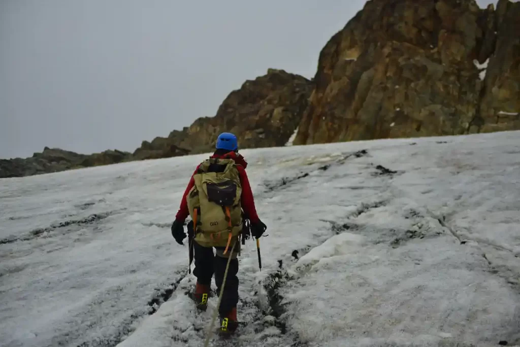
Hikers leave the camp early to make the ascent to Mount Baker’s peak (4,844m). The ascent from Hunwick’s Camp to the summit takes around five hours, while the descent takes about three hours. You’ll stay in Hunwick’s Camp for another night. Throughout your descent, you will retrace your way through Bugata Camp.
HOW WAS MOUNT BAKER formed
The mountains were formed around three million years ago through a process called faulting in the late Pliocene era as a consequence of an elevated block of crystalline rocks containing gneiss, amphibolite, granite, and quartzite. The Rwenzori Mountains are the world’s tallest non-volcanic, non-orogenic mountains.
How long does it take to climb Mount Baker in Uganda?
The ascent from Hunwick’s Camp to the summit takes around five hours, while the descent takes about three hours.
other peaks on Rwemzori mountains
Snow and glaciers covered all six of the Rwenzori’s highest summits as early as 1906. All save Stanley (5,109 m), Speke (4,890 m), and Baker (4,843 m) had snow and glaciers in 2001, although that is quickly dwindling.
Mount Speke
Mount Speke is the second highest peak in the Rwenzori Mountains National Park and is located in the Rwenzori Mountains National Park. Mount Baker and Mount Stanley create a triangle that encircles the upper Bujuku Valley. Mount Stanley is located 3.55 kilometers (2.21 miles) to the south-southwest. These mountains are located in a region known as The Mountains of the Moon.
All of the mountains in this range have several craggy summits. Mount Speke’s peaks include Vittorio Emanuele (4,890 meters (16,040 feet), Ensonga (4,865 metres (15,961 feet), Johnston (4,834 metres (15,860 feet), and Trident 4,572 metres (15,000 feet). Despite the fact that the names were drawn from an Italian royal line, they had to be recognized by the administration of the British Protectorate of Uganda, which administered the region at the time.
When European explorers first visited the region in search of the source of the great Nile, this peak was called after John Speke. Speke drew the source of the White Nile in 1862, despite never hiking this summit. All of the mountains in this region are named after connected explorers who arrived to Africa during the early days of colonization. Mount Speke is pierced by multiple water streams and rivers as a result of the heavy rainfall it receives, and its flora appears thick.
Mount Gessi is located near to Mount Emin in the northern part of Mount Stanley, Speke, and Mount Baker. The peak was named after Romulo Gessi, an Italian adventurer. The mountain, which is separated from Emin by a narrow valley in the Rwenzori Mountains National Park, has twin peaks named Lolanda (15,470 ft.) and Bottego (15,470 ft). (15,418 ft.).
Gessi, at 15018 feet (4578 meters), is one of six Rwenzori summits that comprise the Northern Triangle, along with Mount Stanley, Baker, and Speke. Gessi is also Uganda’s fifth tallest mountain, and it is located along a short canyon that continues southward from Mount Emin.
The mountains are also situated on a rocky north-south axis, with the highest peak facing south. On both the DR Congo and Ugandan sides of Mount Gessi, cottages and slope pathways indicate the route. Climbing to Gessi takes a short trail from Mutsori in Congo to its summit, with the majority of the indigenous tribesmen always there to act as porters and guides. Several shanties have been maintained along the Rwenzori.
The hike to Mount Gessi begins in Mugusu Valley and continues through the forests underneath to Roccato Pass, which travels through thick foliage and slabs. It then takes you to the crest that separates the two peaks. It is also believed that the peak was once covered with glaciers that melted. Duke’s ascending route also melted, and it is now a series of highly mossy steep slabs only fit for novices.
Mount Stanley
Mount Stanley, with an elevation of 5,109 meters, is located in the Rwenzori Mountains National Park (16,763 ft). It is both Uganda’s and Congo’s highest summit.
The Rwenzori Mountains include Mount Stanley. At a height of 5,109 meters, it is the highest point in the Democratic Republic of the Congo and Uganda (16,763 ft). It is also Africa’s third highest mountain, behind Kilimanjaro (5,895 meters) and Mount Kenya (5,199 meters).
This mountain, like several others nearby, has a height high enough to support glaciers. This mountain is named after the novelist and explorer Sir Henry Morton Stanley. Mount Stanley is part of the UNESCO World Heritage Site Rwenzori Mountains National Park.
Mount Stanley has two twin summits and many minor peaks. The Duke of Abruzzi, J. Petigax, J. Brocherel, and C. Ollier made the first ascent of this mountain on June 18, 1906. Mount Stanley is also a high chain of 11 summits that emerge from glaciers, including the Stanley Plateau, the greatest expanse of ice in the Rwenzori Mountains, measuring over one kilometer in length.
The highest mountain, Margherita, may be accessed by trekking from the Elena hut to the first rocks. The path then passes the Stanley Plateau, which is covered in snow and ice, on its journey to Alexandra Peak, the Massif’s second highest peak.
The standard approach to Margherita Peak passes a steep valley on the summit’s eastern face before ascending the breathtaking Margherita glacier to the saddle between Margherita and Alexandra mountains. From here, head north to a short, steep rock wall that climbs to the summit.
Throughout the ascent, a rope will be required for the heavily crevassed glacier as well as the summit rocks. In addition, the summit acts as a natural boundary between Uganda and the Democratic Republic of the Congo. The eastern narrow peak of Alexandra Peak, at 4990 meters, is likewise a spectacular ascent for any mountain trekker.
Savoia Peak, at 4977 meters, crowns another series of mountains to the south. Climbing any of the aforementioned mountains through the legendary tropical glaciers is an unforgettable experience for the Rwenzori Mountains National Park hikers.
Mount Luigi Di Savoia
Mount Luigi di Savoia is a Rwenzori Mountain in Rwenzori Mountains National Park. Its summit, “Sella,” at 4637 feet, is Uganda’s fourth highest and Africa’s sixth highest. Despite the fact that he called it, Mount Luigi is the only mountain in the Rwenzori range that the Duke of Abruzzi did not attempt to climb.
The Duke of Abruzzi is a well-known climber who made the first ascents of Mt. St. Elias in 1897, as well as trekking high on K2 in the Karakoram and almost reaching Bride Peak on Chogalisa. The Abruzzi Rwenzori excursions included treks to all of the Rwenzori summits.
Mount Luigi Di Savoia is a long ridge with a variety of summits, including Stairs Peak (4545 m.), Sella Peak (4627 m.), and Weismann Peak (4627 m.) (4620 m). The less difficult route is from the Fresh Field Pass region, where the northern face of Sella Peak may be ascended to its summit. It is the shortest of the six central mountains and the first to observe the melting of its glacial ice.
HOW TO GET TO mOUNT Baker
Nyakalengija, the trailhead for the Rwenzori Mountains, is located 22 kilometers from Kasese on the Fort Portal – Kampala Route. There are park offices in Nyakalengija where you may pay your park fees.
The Central Circle Trail and the Kilembe Way are ideal choices for those who want to explore the area without trying any mountains. You’ll need about eight days to complete the Central Circuit Trail.
A tour guide is required to see the Rwenzori Mountains. All mountain trips must be accompanied by an experienced mountain crew consisting of a local guide, porters, and a chef, according to policy.
Check out our list of
