Mountains in Uganda
Mountains in Uganda: Uganda is a little known when it comes to mountaineering, its often shadowed by the neighboring countries like Tanzania and Kenya etc. But the fact is that Uganda is one of the few places in the world where you can combine Uganda wildlife safaris and Gorilla trekking through age-old tropical rain forests with adventurous Mountain Climbing. Mountains in Uganda will take you from old age jungles to snow-capped peaks. Mountain climbing in Uganda can be easily combined with Big 5 safaris and if that’s not enough, it’s just an hours and half away flight to Zanzibar for your beach extension.
From climbing the tough 5100m Rwenzori Mountain to summiting the world’s biggest caldera on Mountain Elgon and the beautiful Virunga mountains, mountains in Uganda promises the best and most unique experience you will get on the African continent
Mountain Rwenzori
The Rwenzori Mountains are one of the world’s most exciting yet technical mountains in Uganda to hike. A unique and enchanting realm of 996 square kilometers of fantasy vegetation, lakes, rocky outcrops, cliffs, high glaciers, and snow-capped peaks exists. The summits may not be as tall as larger mountains elsewhere. The highest point – Mount Stanley’s Margherita Peak – is 5,109 meters (but this is still Africa’s 4th highest peak!). However, their isolated position, changeable weather conditions, shockingly diversified vegetation, remoteness, vistas, and low tourist numbers all combine to excite daring trekkers eager for a once-in-a-lifetime experience. Rwenzori mountain is one of the mountains in Uganda with unique vegetational composition.
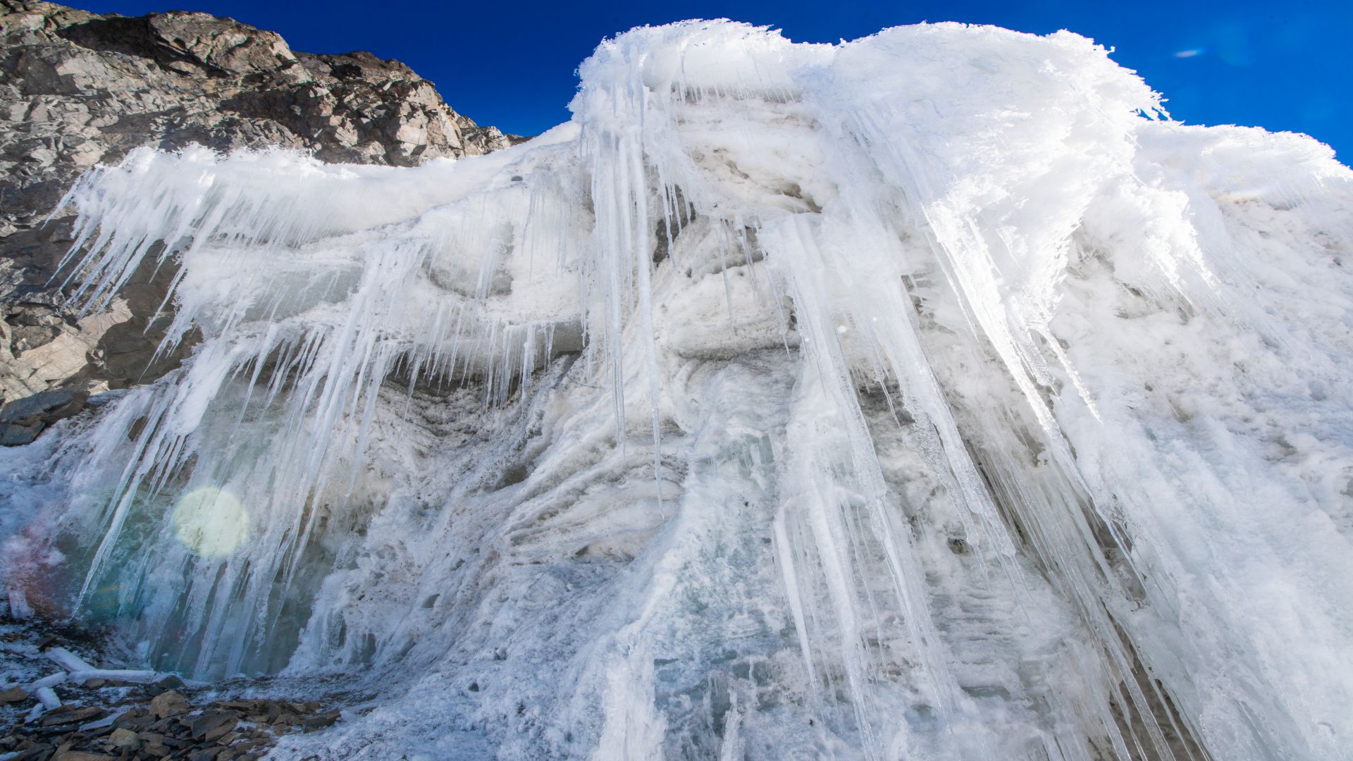
The Rwenzori Mountains became a national park in 1991, a World Heritage Site in 1994, and a Ramsar site in 2008. These designations attest to the mountains’ international scientific significance. The name ‘Rwenzori’ approximately translates as ‘Rainmaker,’ emphasising the mountains’ significance in East and Central Africa. The environment is moist since the mountains receive more than 3 meters of rain yearly. This results in luxuriant vegetation on the lower slopes and snow and ice on the upper levels. Even though glaciers have receded dramatically over the previous century owing to climate change, climbers during the rainy season will still have to cross ice walls and substantial snowfall to reach the peaks.
Mountain Rwenzori
Activities on Mountain Rwenzoris Uganda
Mountain Rwenzori Hiking
Rwenzori Mountains Hiking: The Rwenzoris must be toured on foot, and you must be physically healthy and accustomed to endurance exercises. Margherita Peak has recently been classed as a technical climb, and while you don’t need to be an expert climber to complete it in winter conditions, some prior expertise is suggested. From ‘peak baggers’ to birders looking to track down the region’s rare species, a wide range of treks from one to twelve days are available.
Routes can also be extended for private groups to allow for additional time acclimating to the altitude or simply enjoying the calm, seclusion, and beauty of the highlands. The Rwenzori peaks can be reached by two trekking circuits; the Central Circuit from Nyakalengija and the Southern Circuit from Kilembe. Rwenzori is one of the most technical Mountains in Uganda. While Professor Scott Elliott pioneered the Southern Circuit in 1895, it was the Central Circuit, pioneered by Luigi di Savoia in 1906, that gave the only access to the highlands for many years.
Cultural encounters
A lot of cultural communities can be found in all the Mountains in Uganda. For nearly 300 years, the Bakonzo lived in Mihunga, a little settlement on the slopes of Mountain Rwenzori. One may argue that the spectacular vistas of the snowcapped peaks are why they chose this position for their community. The Bakonzo adapted to living on the slopes of this enormous mountain without power or running water. They were self-sufficient, using local herbs for treatment and farming for food. You will visit the Mihunga community tourism organization as part of your cultural trip. The rapid evolution into modernism in our day has undermined old ways and practices. Bakonzo cultural organization was formed in order to promote and preserve the Bakonzo heritage. Follow the trek across the rugged landscape to the Mubuku river, whose waters inspired the name Ruboni (crystal clear water). The trail follows the flow of water. Meet locals bringing their harvest and firewood, a Bakonzo way of life. Watch for Rwenzori Turaco, gorgeous francolin, sunbirds, cinnamon-chested bee-eaters, and other magnificent bird species. This nature walk includes primates such as colobus monkeys, red-tailed monkeys, and vervet monkeys.
Mountain Stanely - Highest Mountain in Uganda ( Mt Rwenzoris )
This is the highest Mountain peak in Uganda standing at 5109 meters above the sea level. It also has the record of being the 3rd highest mountain in Africa just after Mt Kilimanjaro that has 5895 meters, Mount Kenya standing at 5197 meters.
Margherita Peak on Mounta Stanley:
The Margerita peak (highest point in Uganda ) and the 3rd in Africa is on Mount Stanley and that is one of the largest glaciers in Africa before arriving on the rock on the highest summit of the Rwenzoris. Unfortunately the ice is melting at a very high rate with fears that it will completely disappear in the next 30 years.
Trekking the Rwenzori mountains to the highest peak usually requres atleast 7 day to reach margherita peak ( 5109 meters)
Mountain Elgon: Mountains in Uganda
Mountain Elgon is one of the fascinating Mountains in Uganda. Mount Elgon National Park, located on the Kenyan-Ugandan border, is named after Mount Elgon, an extinct shield volcano that erupted more than 24 million years ago. Mountain Elgon boasts the world’s most excellent surface area of any extinct volcano, and its 4,321m peak is Africa’s sixth tallest. The Ugandan section includes 1,110km2 of the park’s 1,279km2 surface area, whereas the smaller Kenyan section spans 169km2. Mountain Elgon National Park is teeming with animals. Elephants, buffalo, and a variety of tiny antelope live on Mountain Elgon’s lower slopes.
Primates like the black-and-white colobus monkey and the blue monkey can be found in the deep highland forest. The park also has around 300 bird species, including the Tacazze sunbird and the lammergeier. The Sabiny and Bagisu tribes live in Mount Elgon National Park. The Sabiny speak Sebei, a Nilotic language, and the Bagisu speak Lugisu, a Lumasaba dialect. The Bagisu regard Mountain Elgon as an embodiment of their founding father, Masaba, and refer to it as such. Subsistence farming is practiced by both groups.
Mountain Elgon Hiking Trail in Uganda
One of Mount Elgon’s main draws are its hiking routes. Unlike other climbs in East Africa, Mount Elgon’s routes are open all year and do not require any special climbing equipment. The hiking routes on Mount Elgon are less crowded than other hiking trails in East Africa, allowing you to appreciate the spectacular view without distractions. The three primary hiking trails on Mount Elgon differ in length and difficulty
The Sasa Trail - Mountain Elgon Uganda
Sasa Trail in Uganda’s Mountain Elgon is the shortest but most challenging trail, lasting four days round trip. This is the original route up Mount Elgon’s 4,321m peak, Wagagai. The path begins at an elevation of 1,250 meters in the town of Budadiri in Uganda’s Eastern Region. The first day begins with a 1,650m rise. The trail then enters the jungle, leading to the Mudangi Cliffs, which are reached via ladders. Then there’s a 2.5-hour trek through a beautiful bamboo forest. Day 2 is a milder hike, while Day 3 brings you to Wagagai.
The Piswa Trail - Mountains in Uganda
Piswa trail on Mountain Elgon is a gentler alternative to the Sasa Trail. Over seven days, you will travel approximately 49 kilometers. The trail begins at an elevation of 2,190 meters near the settlement of Kapkwata on the mountain’s north flank. The trail is well-known for its breathtaking vistas of the Karamoja Plains in Uganda and the Kapeguria and Nandi Hills in Kenya
Sipi Trail Mountain Elgon Trail
The Sipi trail is the longest trail. It is 56 kilometers long and takes 4-6 days to complete. The trail starts at the Kapkwai Forest Exploration Centre, just a few kilometers from Sipi Falls. The portion through Tatum Cave, noted for its ancient cave paintings, is one of its attractions. The Forest Exploration Centre has opened three shorter paths ranging from 3 to 7 kilometers. These trails are ideal for inexperienced hikers and visitors who want to enjoy Mount Elgon’s stunning beauty and animals in a short time.
Mount Elgon National Park is home to over 300 bird species and has been designated as an Important Bird Area (IBA). Bird enthusiasts should keep an eye out for endangered species such as the lammergeier. Keep an eye out for the African blue fly-catcher, African goshawk, and cinnamon-chested bee-eater.
Mountain Moroto: Mountains in Uganda
Mount Moroto is located in far eastern Uganda and is the most easily accessible destination for viewing some of the northeastern notable bird species. Most are located along the western border of their ranges, which begins with Mount Elgon in the south and Mountain Kadam and Morungole. Moroto is a forest reserve that protects various habitats ranging from dry thorn savanna to arid montane forest. Even though a long climb is required to reach the upper elevations, beautiful dry thorn savanna and rocky slopes may be observed from the village at the mountain’s base.
Mountain Moroto hiking can easily be combined to your safari in Kidepo valley National Park thats 4 hours away or camping tour in the Karamoja’s Pian Upe plains. The region is beaming with alot of attractions that are waiting to be discoverer. There are very few tourists that have ventured in the far east because of decades of isolation due to conflicts. This has changed and its time you discover this Uganda’s best kept secret.
What to Do around Mountain Moroto
As we mentioned earlier, Mountain Moroto is located in Karamoja region that is beaming with a lot of attractions from authentic and untouched tribes to untamed wilderness camping, wildlife safaris and endless hiking opportunities. Here are some of the activities you can do apart from Hiking Uganda’ Mountain Moroto
Cultural & Tribal Experiences
Other than hiking the Mountains in Uganda, you can explore the authentic culture of the people who reside around or on the mountains in Uganda. Situated on flat elevated areas that is between that mountains of South Sudan and Kenya Turkana region, Karamoja is home to unique worriers still living a simple life as it has been for centuries. They live in extremely dry climate with beautiful scenery with cattle being the most prized thing in their culture.
On your visit here, you will encounter local tribes wearing colorful blankets, beads marked with special piercing and markings. The Karamajongs are totally different from other Ugandan tribes. Cattle rustling from neighboring Kenya and South Sudan was until recently a cause of conflict in the region. The region remains one of the least developed and isolated regions in Africa with very few tourists have ventured here.
Bird Watching
Apart from hiking, birding is one of the most popular safari activities done around the Mountains in Uganda. The neighboring Pian Upe Reserve, is a birders paradise that you should not miss on your destinations is your passion. The bird list here is simply amazing. You will see many birds here that are not easily seen any where else on a typical birding tour.
Lake Opeta and Lake Bisina from the Kyoga system’s eastern extension are among the best places to witness Uganda’s only endemic bird species, the Fox’s Weaver. Despite the lack of infrastructure, the lakes can be seen on your route from Mount Elgon to Moroto or toured for a day from Soroti or Mbale. Lake Bisina is the more accessible of the two locations, accessible by an excellent dirt road that branches north off the Mbale-Soroti main road near Kapiri. The numbers are most outstanding in March and April, but there are a few seen throughout the year. Lesser Jacana and African Pygmy Goose can be found in quieter water areas with lilies. Furthermore, the Shoebill is relatively common around the rim of the broad papyrus.
The Brubru and Eastern Violet-backed Sunbirds, the beautiful Silver bird, the White-bellied Go-away Bird, Pygmy Batis, Jackson’s Hornbill, Mouse-colored Penduline Tit, Fawn-colored Lark, Yellow-bellied Eremomela, and the African Grey Flycatcher live in the thick thorn savanna near the T-junction along Mbale road 11 kilometers from town. Spot the exquisite Black-headed Plover, Dark Chanting Goshawk, Crested Bustard, and Yellow-necked Spur bird. Temminck’s Courser and Plovers may be seen at the nearby airstrip. D’Arnaud’s Barbets in pairs are frequently engrossed in their unusual tail-wagging duets. Take note of the distinct sound of the Pebbles being struck together, which could signal the presence of the Grey Wren Warbler.
Mountain Sabinyo;Mountains in Uganda
Mount Sabinyo is an extinct volcano in the Virunga Mountains. Mount Karisimbi, Muhabura, Bisoke, Mikeno, Nyiragongo, Gahinga, and Nyamuragira are also part of the Virunga ranges. Mount Sabinyo is separated from its nearest neighbor Muhabura by a 20-meter-diameter crater lake. Sabinyo translates as “Old man’s tooth” in the native tongue. This is because its jagged summit resembles worn-out teeth compared to the flatter summits of nearby mountains.
Mount Sabinyo stands at 12,037 feet tall and serves as a boundary for the three countries of Uganda, Rwanda, and the Democratic Republic of the Congo. Mountain gorillas, elephants, buffaloes, and other forest antelopes live on the mountain slopes, as do endangered mountain gorillas. Mount Sabinyo is one of the most difficult hikes in the Virunga Ranges of mountains. It has multiple ridges due to its rough slopes and craters on the sides. This mountain range is one of the most spectacular mountains in Uganda.
Hiking Mount Sabinyo is currently only possible from Uganda due to the lack of a way through the rocky peaks on the Congo and Rwanda sides. The Rwandan government intends to carve a path across the craters and hills so that tourists can begin their trip in Rwanda. Every hiker is handed a walking stick; treat it like treasure. Porters might be hired for individuals with heavy equipment such as cameras. Aside from the official Guide, an armed ranger is always present to scare away huge mammals such as elephants that graze on the mountain’s slopes.
Following the briefing, you will begin by going through a level landscape with various marshes. For the next 2390 to 2800 meters, you begin ascending to a region with dense vegetation zones. This location, which is mostly bamboo, is a favorite of golden monkeys.
Aside from monkeys, you might see mountain gorillas, elephants, and buffaloes in this area. After the first zone, you’ll come across a sub-alpine environment with fewer trees but home to the endangered Rwenzori Turaco. The Rwenzori Turaco is a lovely bird that is popular among birders. It can only be found in the Albertine rift zone. By the time you finish this zone, you should be able to see the summit ahead.
Sabinyo is the only mountains in Uganda that allows you to view the 3 countries of Uganda, Rwanda and Congo all at once while enjoying some of the nicest views you’ll ever see – weather permitting. The picturesque Lake Kivu in Rwanda and the Democratic Republic of the Congo may be seen from the summit. Lake Bunyonyi in Uganda, the Rwenzori Mountain ranges in Uganda, over six mountains in the Virunga region, and numerous other sights are also visible.
Human settlements can also be spotted among the lush green plantations and woodlands. Congo appears to be abandoned, whilst Rwanda appears to be more heavily populated. Descending is easier but also more difficult. You must deal with ladders once more, and you must do so with caution, especially if the weather is poor.
Mountain Gahinga: Mountains in Uganda
Mount Gahinga is one of eight volcanoes found in the Virunga Mountain ranges, which span three countries: Rwanda, Uganda, and the Democratic Republic of the Congo. This extinct volcano stands 3,474 meters tall and is located between Uganda and Rwanda. The mountain is located in Uganda’s Mgahinga National Park in the Kisoro District. Mount Gahinga is located between Mt. Muhabura and Mt. Sabinyo. It is the smallest of Mgahinga National Park’s three volcanoes. In the local languages, “Gahinga” refers to a tiny mound of stones around the mountain. The mountain contains a 180m wide caldera. The mountain slopes are largely covered in bamboo and sub-alpine flora. Primates such as mountain gorillas, golden monkeys, blue monkeys, Vervet monkeys, baboons, and black and white Colobus monkeys thrive on the bamboo in this section of the mountain.
Hiking Mountain Gahinga / Mountain Mgahinga in Uganda
Mount Gahinga is a gentler hike than Mount Sabinyo or Muhabura. To accomplish the hike, however, one must be physically and emotionally prepared. Depending on the hiker’s determination and fitness, the activity takes 6 hours to accomplish. A hiking permit from the park authorities is required to participate in the hike. The permits are $75 and can be purchased on the day of the hike. There is no need to make a reservation in advance. The hike to Mount Gahinga begins at 7:00 a.m. with a briefing with one of the park Rangers at the park headquarters. The Rangers educate visitors about the mountain’s history and location amid the Virunga volcanoes. Hikers will be informed about the nature of the hike and how to best prepare for it. Hikers can rest, dine, take photos, and enjoy the lovely landscape at numerous spots along the mountain. Following the briefing, everyone is given a free hiking stick, and those who choose to employ porters can do so.
The first portion of the journey takes you through a dense bamboo grove near the mountain’s base. Because the ground is level, this segment is pretty simple. This is also where you will most likely encounter golden monkeys, gorillas, and other primates. Buffaloes frequent the mountain slopes and can be deadly to hikers. It is one of the reasons why hikers are usually accompanied by an armed Ranger. The mountain becomes steeper after the bamboo groves until it reaches the summit. By the time one reaches the summit, they will have passed through multiple bat-infested volcanic caves and other volcanic features on the mountain slopes.
Mountain Gahinga’s summit is distinct from those of Sabinyo and Muhabura due to its unique summit. A vast shallow crater wetland with unusual sub-alpine plants like Senecio, Lobelia flourish, and Alchemilla is be found at the peak.
The peak provides breathtaking views of the other distant volcanoes in the Virunga and Rwenzori ranges. Mount Mahabura and Sabinyo may be seen well, tempting you to climb to their summits in the coming days. Take as many shots as you can of your groups and distant scenes. Descending is significantly easier than climbing. However, attention is required, especially when climbing down ladders, to avoid sliding or falling down.
Mountain Gahinga: Mountains in Uganda
Mountain Muhabura, also known as “Muhavura,” is an extinct volcano located on the boundary between Uganda, the Democratic Republic of the Congo, and Rwanda. In other words, one part of the volcano is located in Uganda’s Mgahinga National Park, while the other is in Rwanda’s Volcanoes National Park. The mountain features the third highest summit in the Virunga Ranges of mountains, standing at 4,127 meters above sea level. Mikeno is the tallest, followed by Mount Karisimbi. Muhabura, on the other hand, is the steepest of the eight Virunga Volcanoes. Mount Muhabura is a short distance from Mount Sabinyo and Mount Gahinga.
In the native tongue, Muhabura means “the guide.” This moniker was most likely coined as a guide for distant travelers. Mount Muhavura has a cone-like shape and is covered in volcanic ash and other associated materials on the slopes and at the base. The volcanic ash supports the bushes and thickets that grow on the mountain faces. Another notable feature that divides Mountain Muhabura and Gahinga is the Kabiranyuma river/swamp.
Mountain Muhabura provides an opportunity to see rare bird and mammal species such as buffaloes, elephants, and mountain gorillas, particularly from the Uganda side. Because buffaloes are naturally hostile, they can be dangerous to hikers, but armed rangers are always on hand to scare them away just in case.
Hiking Mountain Muhavura in Uganda
Mount Muhabura is the hardest of the eight volcanoes in the Virunga Ranges to climb. Although it is not the tallest, it is exceedingly steep, and the hike must be completed in one day (before the sun sets). To reach the summit and return safely, one must be mentally prepared and perhaps a little stubborn.
Hiking Mount Muhabura is possible in both Uganda and Rwanda. If you ascend Mount Muhabura from the Uganda side, you will be met by Uganda Wildlife Authority guides and escorted to the Ntebeko Visitors Centre. If you are hiking from Rwanda, you must report to the Kinigi visitors center, where you will pay for the hike. After paying at the office, your group will be allocated a Guide and ranger who will lead you all the way up the mountain. Porters are available for hire at the mountain’s base if you haul large luggage or equipment.
In large groups, hikers are frequently divided into two groups: slow hikers and seasoned/experienced hikers. If it is too late and you are not close to the summit, you should simply give up and descend with the others who finished on time.
Climbing Mount Muhabura begins at about 7 a.m. and takes between 5 and 7 hours. The Rangers will conduct a briefing for all hikers before departing for the main trek. This briefing covers all critical components of the trip, including the mountain’s history and structure. The Rangers will advise hikers on how to mentally prepare for the exercise as well as how to deal with any injuries or indications of altitude disease.
During the briefing, the Rangers and Guides will also ensure that all hikers have the necessary equipment, including hiking boots, walking sticks, packed lunch, appropriate clothing, drinking water, and a walking stick. Before traveling to the head trail, all supplies and equipment must be sorted.
Hikers are driven or brought to the starting point of the hike by park authorities, their personal driver, or a Guide/Driver from their Tour company after the normal briefing.
Mount Muhavura is a difficult hike due to its steepness. To finish the hike, one must be physically fit. In Uganda, the cost of climbing Mountain Muhabura is $75 per person. This fee does not include transportation, lodging, or porters. The porters must be paid separately. Mountain Muhavura climbing permits can be obtained on the same day as the hike in both Uganda and Rwanda.
Before reaching the peak of Mountain Muhabura, hikers must make two important stops in Uganda. The first stop is around 3,117 meters above sea level, while the second is approximately 3,860 meters above sea level. Many hikers do not make it past the first rest stop (hut). They merely rest, have their lunch, and conclude that enough is enough before returning to where they began. In fact, in most cases, only about 50% of the people reach the top. Those who continue must face a more arduous walk to the second shelter (stop).
The hike becomes increasingly difficult after the second stop. But there’s no going back now because the peak is so close. Continuing from here needs greater stamina, commitment, and a certain degree of fitness. It gets colder, and the peak is frequently shrouded in mist. At this stage, some people may get altitude sickness or ankle problems.
Those that reach it all the way to the top after such a difficult trek are rewarded with spectacular landscapes, lush countryside, lakes, and other Virunga range volcanoes like Sabyinyo, Gahinga, Karisimbi, Bisoke, and Nyiragongo. The top gives you the sensation of being utterly removed from reality. It is possible to see primates, birds, and even large forest creatures like buffaloes and elephants. The peak also has a crater lake with magnificent clean waters. Hikers can swim in the lake, but most are discouraged by the frigid water.
The picturesque twin lakes Ruhundo and Burera may be seen from the Rwandan side, while Lake Bunyonyi can be seen from the Ugandan side. Unfortunately, cloud cover and mist can obscure views of distant volcanoes during certain months of the year. If the hikers climb slowly, they will have little time to spend on the mountain. The Rangers will ask you to leave the top early to avoid encountering forest mammals such as buffalo or descending in the dark.
A group photo with all participants is required before climbing down. It is difficult to descend the mountain. In fact, for some, it is just as difficult as climbing up.
It’s incredibly slippery coming down, and this second section is encountered when your body is exhausted from the ascent. At this time, the legs and body joints would be in discomfort, and descending puts extra pressure on the body joints. Furthermore, even after reaching the mountain’s base, you will have to pass through gardens and human communities before returning to the office or meeting your Driver/Guide.
Mountain Gahinga; Mountains in Uganda
Mountain Morungole, located on the southeastern edge of Kidepo Valley National Park, stands over some of Karamoja’s most remote areas at an impressive 2,750m. Locals claim that the rocks could topple over Kaabong at any time. This mountain is home to the Ik, Uganda’s smallest tribe. It further holds enormous spiritual value for the people who live on its slopes, and the hallowed summit is inaccessible to tourists.
Hikers will, however, appreciate a trek to other summits, which will be made valuable by the cultural experience of strolling among the Ik people, as well as the panoramic vistas of the Karamoja plains and the Eastern Rift Valley. The Ik were compelled to relocate to the slopes of Mountain Morungole after the surrounding lands were designated as a national park. They have preserved their distinct and proud tradition in the hills of their sacred mountain.
The hike up Mountain Morungole takes around 2-3 hours, and the descent takes about 1.5 hours. Be aware that, while theoretically easy, this hike will take you along some fairly steep and woody slopes. It is strongly advised that you hire a local guide(s) for this hike. Mountain Morungole trail passes through many Ik homesteads. Having an Ik or Karamojong guide helps to eliminate misunderstandings.
Mountain Morungole: Mountains in Uganda
Mountain Morungole, located on the southeastern edge of Kidepo Valley National Park, stands over some of Karamoja’s most remote areas at an impressive 2,750m is one of the mountains in Uganda. Locals claim that the rocks could topple over Kaabong at any time. This mountain is home to the Ik, Uganda’s smallest tribe. It further holds enormous spiritual value for the people who live on its slopes, and the hallowed summit is inaccessible to tourists.
Hikers will, however, appreciate a trek to other summits, which will be made valuable by the cultural experience of strolling among the Ik people, as well as the panoramic vistas of the Karamoja plains and the Eastern Rift Valley. The Ik were compelled to relocate to the slopes of Mountain Morungole after the surrounding lands were designated as a national park. They have preserved their distinct and proud tradition in the hills of their sacred mountain.
The hike up Mountain Morungole takes around 2-3 hours, and the descent takes about 1.5 hours. Be aware that, while theoretically easy, this hike will take you along some fairly steep and woody slopes. It is strongly advised that you hire a local guide(s) for this hike. Mountain Morungole trail passes through many Ik homesteads. Having an Ik or Karamojong guide helps to eliminate misunderstandings.
Mountain Kadam: Mountains in Uganda
This mountain is one of the hidden gems in regards to Mountains in Uganda. The yet to be discovered Mount Kadam in Uganda will reward you with spectacular climbing opportunities and beautiful and unique tribal experience. Numerous tribes live on the mountain, including the Kadama, Sebei Pokot, Karamojong, Gishu, and Tepeth. The mountain is a part of the Pian-upe Wildlife Reserve the second biggest wildlife reserve in Uganda. The trails are so beautiful and pass through some of the most isolated tribes on the African continent that one must not miss on their Uganda safaris
