DISCOVER UGANDA
Mount Luigi Di Savoia in Rwenzori Mountains National Park
Mount Luigi di Savoia is one of the Rwenzori Mountains in the Rwenzori Mountains National Park. Its summit, “Sella,” at 4637 feet, is the fourth highest in Uganda and the sixth highest in Africa.
Mount Luigi di Savoia is one of the Rwenzori Mountains in the Rwenzori Mountains National Park. Its summit, “Sella,” at 4637 feet, is the fourth highest in Uganda and the sixth highest in Africa. Mount Luigi is the only mountain in the Rwenzori range that the Duke of Abruzzi did not attempt to climb, despite the fact that he named it.
Mount Luigi Di Savoia, like the other Rwenzori mountains, consists of a long ridge with several summits, including Stairs Peak (4545 m), Sella Peak (4627 m), and Weismann Peak (4620 m). The less demanding path is from the region within the Fresh Field Pass, where the northern aspect of the Sella top may be climbed to its top. It is the shortest of the six central mountains and the first to see its glacial ice melt.
The Duke of Abruzzi is one of the most well-known mountaineers, having made the first ascents of Mt. St. Elias in 1897 and hiking high on K2 in the Karakoram and almost reaching the Bride Peak on Chogalisa. Abruzzi Rwenzori expeditions featured walks to all Rwenzori Peaks. He was also a military hero, saving many Yugoslav refugees from Albania during World War I, and he lived his later years in Ethiopia, where he was well-liked.
Other Peaks in the Rwenzori Mountains.
Mount Gessi
Mount Gessi is located in the northern section of Mount Stanley, Speke, and Mount Baker, close to Mount Emin. The summit was named after the Italian explorer Romulo Gessi. The mountain, located in the Rwenzori Mountains National Park and separated from Emin by a short valley, features twin peaks named Lolanda (15,470 ft.) and Bottego (15,470 ft.). Gessi, at 15018 feet (4578 meters), is one of six Rwenzori peaks that make up the Northern Triangle, which also includes Mount Stanley, Baker, and Speke. Gessi is Uganda’s fifth tallest peak, and it’s located in a narrow canyon that leads south from Mount Emin.
The mountains are likewise oriented north-south, with the tallest peak facing south. Cottages and slope walkways mark the route on both DR Congo and Ugandan sides of Mount Gessi. Climbing Gessi requires a short path from Mutsori in Congo to the peak, with the bulk of indigenous tribesmen always present to function as porters and guides. Several shanties have survived along the Rwenzori. The climb to Mount Gessi starts in Mugusu Valley and continues through the forests underneath to Roccato Pass, which passes through dense trees and slabs. The path eventually leads to the summit that divides the two peaks. It is also thought that the mountain was previously covered with melting glaciers. Duke’s ascent path has likewise melted, and it is now a succession of mossy steep slabs only suitable for beginners.
Mount Speke
Mount Speke, located inside the Rwenzori Mountains National Park, is the second-highest mountain in the park. Mounts Baker and Stanley create a triangle that encircles the upper Bujuku Valley. Mount Stanley is 3.55 kilometers (2.21 miles) to the south-southwest. The Mountains of the Moon region include these mountains. The mountains in this range all have jagged summits. Mount Speke’s peaks (15,000 feet) include Vittorio Emanuele (4,890 meters (16,040 feet), Ensonga (4,865 meters (15,961 feet), Johnston (4,834 meters (15,860 feet), and Trident 4,572 meters.
Despite the fact that the names were drawn from an Italian royal line, the authorities of the British Protectorate of Uganda, which administered the region at the time, needed their recognition. When European explorers first visited the region in search of the source of the great Nile, they called this peak after John Speke. Despite never having visited this summit, Speke portrayed the White Nile’s source in 1862. The mountains in these areas are all named after related explorers who arrived in Africa during the early days of colonization. Mount Speke is pierced by numerous water streams and rivers as a result of the regular rains, and its flora appears thick.
When European explorers first visited the region in search of the source of the great Nile, they called this peak after John Speke. Despite never having visited this summit, Speke portrayed the White Nile’s source in 1862. The mountains in these areas are all named after related explorers who arrived in Africa during the early days of colonization. Mount Speke is pierced by numerous water streams and rivers as a result of the regular rains, and its flora appears thick.
Mount Baker
Mount Baker is located in the Rwenzori Mountains National Park in Uganda. It lies 2.8 kilometers from the border of Uganda with the Democratic Republic of the Congo. The summit, known locally as Kiyanja, stands at 4,844 meters (15,892 feet), making it Africa’s sixth-highest mountain. Along with Mount Speke and Mount Stanley, the trio forms a triangle that encircles the upper Bujuku Valley. Mount Stanley is the nearest summit, located 2.26 kilometers (1.40 mi) to the west. The mountains are in an area known as “The Mountains of the Moon.” Mount Baker features several steep peaks, as do all of the summits of the Rwenzori Mountain Range, the highest of which is Edward Peak.
In January 1906, Austrian climber Rubert Grauer hiked to Mount Baker’s height line with two British missionaries, H. W. Tegart Addox and H. E. M. Between February and April, an English excursion team led by A. B. Wosnam, Alexander F. R. Wollaston, and M. Carruthers visited the same rock-strewn region. The summit of Mount Baker was ultimately reached in June 1906 by an expedition commanded by the Duke of Abruzzi. This party hiked to the tops of the Rwenzori’s other five highest peaks. On his way into the Ruwenzori in June 1891, Franz Stuhlmann observed the mountain and named it either Ngemwimbi or Semper. Abruzzi named the summit after Samuel Baker, a British explorer who was the first European to notice and visit Lake Albert in the Rwenzori Mountains in 1864. Baker also reported seeing “huge mountainous masses in the distance, to the south of Lake Albert.”
Mount Stanley
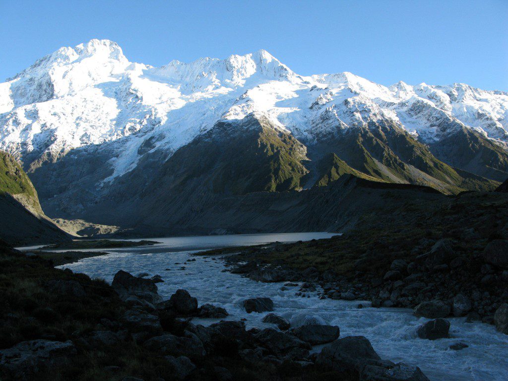
Mount Stanley (5,109 meters) is located in the Rwenzori Mountains National Park (16,763 feet). It is the highest point in both Uganda and Congo. Mount Stanley is part of the Rwenzori Mountains. It is the highest peak in the Democratic Republic of the Congo and Uganda (16,763 ft) at 5,109 meters. It is also Africa’s third-highest peak, after only Kilimanjaro (5,895 meters) and Mount Kenya (5,199 meters). Like numerous others in the area, this peak is tall enough to host glaciers. This mountain is named after Sir Henry Morton Stanley, an author, and adventurer. Mount Stanley is part of the Rwenzori Mountains National Park, a UNESCO World Heritage Site.
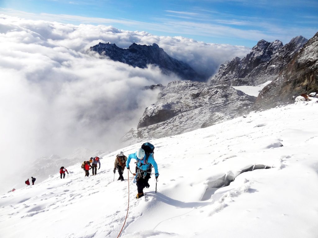
Mount Stanley features two twin summits as well as several lesser peaks. On June 18, 1906, the Duke of Abruzzi, J. Petigax, J. Brocherel, and C. Ollier performed the first climb of this peak. Mount Stanley is also a high chain of 11 peaks that rise from glaciers, including the Stanley Plateau, the longest area of ice in the Rwenzori Mountains at over one kilometer in length. Margherita, the highest peak, may be reached by walking from the Elena hut to the first rocks. The trail then goes across the snow-covered Stanley Plateau on its way to Alexandra Peak, the Massif’s second-highest peak.
The usual approach to Margherita Peak climbs via a steep valley on the summit’s eastern flank before ascending the spectacular Margherita glacier to the saddle between Margherita and Alexandra summits. Head north to a short, steep rock wall leading to the peak. A rope will be necessary for the badly crevassed glacier as well as the summit rocks during the ascent. The peak also serves as a natural border between Uganda and the Democratic Republic of the Congo. Alexandra Summit’s eastern narrow summit, at 4990 meters, is also a beautiful accent for any mountain trekker. At 4977 meters, Savoia Peak heads another range of mountains to the south.
About the Rwenzori Mountains in Uganda.
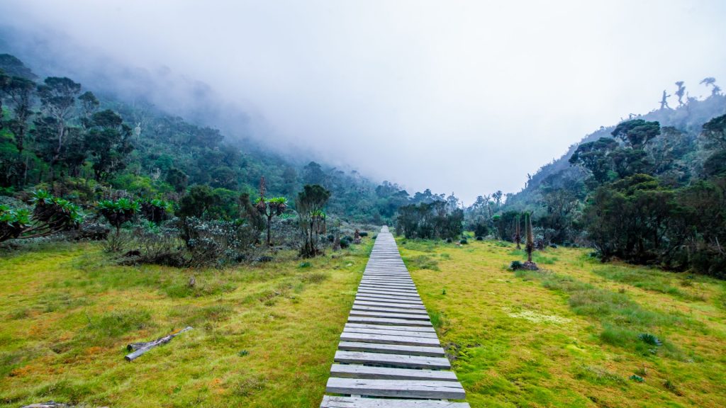
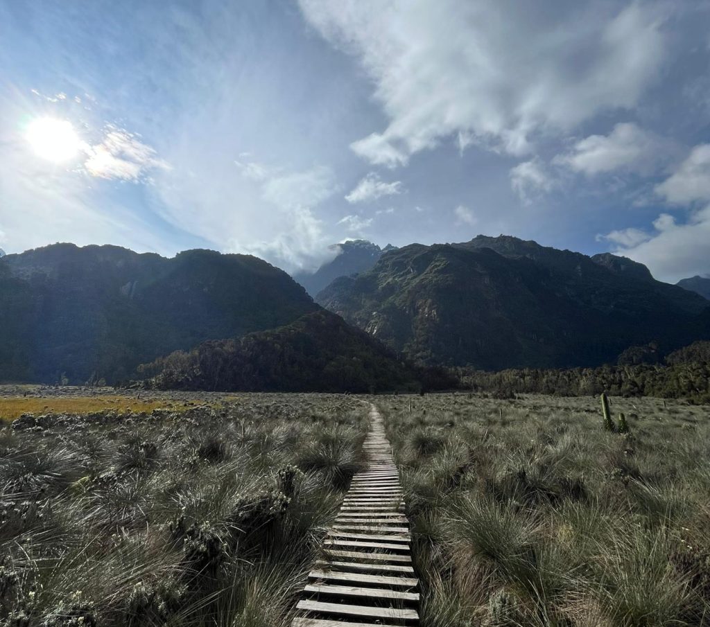
The Rwenzori Mountains are about 120 kilometers long and 65 kilometers broad. It consists of six summits separated by steep gorges: Mount Stanley (5,109m), Mount Speke (4,890m), Mount Baker (4,843m), Mount Emin (4,798m), Mount Gessi (4,715m), and Mount Luigi di Savoia (4,627m). Mount Stanley features several lesser summits, the tallest of which is Margherita.
The Rwenzori Mountains in Uganda are an excellent trekking and mountaineering location. A 7- to the 12-day trip will get both skilled and inexperienced hikers up the top and out of the park. However, for shorter and less rigorous treks, there are nature hikes through Bakonzo Village, farmhouse visits, cultural performances, and other traditional activities, as well as the 2 to 3-day 28km Mahoma Nature route.
Hiking Trails on the Rwenzori Mountains
The Central Circuit on the Rwenzori Mountains.
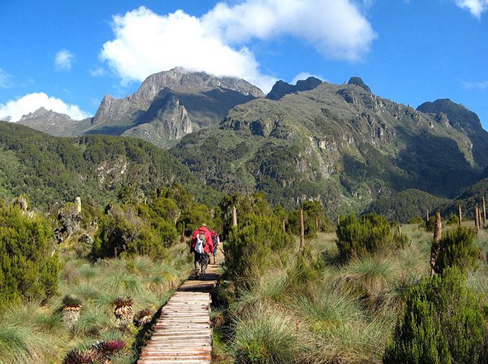
The core circuit path is the oldest and most ancient trail utilized by both skilled and inexperienced hikers to reach the summit of Margherita Mountain. This excellent trek traverses the five vegetation zones of the Rwenzori Mountains National Park, offering amazing encounters as it follows the 1000m tropical valleys and gorges as it ascends to the granite summit of Mount Stanley. The Central circuit track, which spans the lower and upper Bigo bogs, is the fastest and simplest access route to Margherita summit, as opposed to the marshy path beyond John Maate camp.
The Kilembe Trail on the Rwenzori Mountains.
The (RTS) owns and manages the Kilembe path, often known as the southern circuit. This path was just opened for tourists with the construction of new huts within the National Park, despite Professor Scott Elliott discovering it in 1895. The Kilembe trail, the longest route allowing for adequate acclimatization, provides the finest climbing experience of the majestic peaks, spectacular lakes, breathtaking glaciers, and the flora and fauna.
This path has received rave reviews for its professionalism, quality equipment and safety precautions, as well as the new pleasant cottages located along the route. It takes 7- 8 days to hike to Margherita Peak, which is equal to the Bukurungu wilderness camping track.
The Bukurungu Trail on Rwenzori Mountains.
The Bukurungu path was built after the Central Circuit and Kilembe routes. The path is great for individuals who enjoy the outdoors since it features four lovely lakes (Mughuli, Bukurungu, Bujuku, and Irene) as you journey past mountain rivers, waterfalls, and lush vegetation. This journey, like Kilembe, takes 8 days to complete including a must-see stop at Margherita Peak.
The Bukurungu path, unlike the Kilembe and Central circuit trails, is an open track used for camping with no shelters but rather safe and secure camping spots carefully planned and administered by the Bujuku Eco tours under Rwenzori Mountains National Park.
When is the best time to hike the Rwenzori Mountains?
The best months to visit/climb/hike/trek Rwenzori Mountains National Park are June to August and December to February, however, it may be visited all year. For mountaineers, the months of June to August are ideal for attempting an ascent of Mountain Rwenzori’s Margherita Peak.
Tips for hiking Peaks in the Rwenzori Mountains.
We all feel that everyone may enjoy trekking in the Rwenzori Mountains, but there are certain fundamental guidelines to make the journey more enjoyable. In this post, we’ll go over the greatest Rwenzori Mountains National Park hiking tips, methods, and travel hacks. Here is our top advice for successfully climbing and summiting the Rwenzori Rwenzori Mountains;
Skill Level, Physical Strength, and Age
There is no need to be concerned if you are a beginner, however, it will be much more pleasant if you are physically strong enough to climb the Rwenzori Mountains. Except for the age requirements, which require that you be at least 12 years old, you do not need to be taught by a tour guide to climb the Rwenzori mountains.
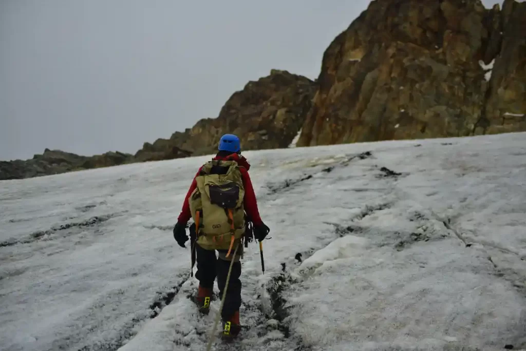
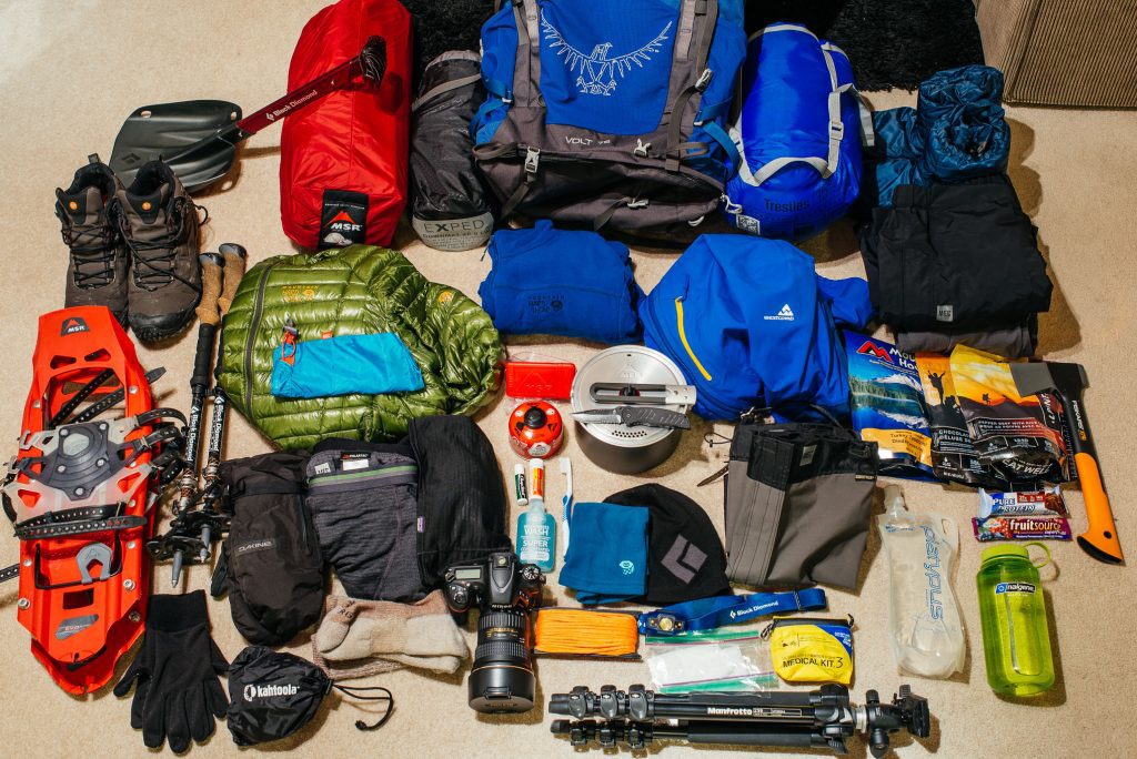
Pack the right Gear
When climbing in the Rwenzori Mountains National Park, having the correct equipment is vital. There are several items that we believe you should bring with you when hiking, including headlamps, waterproof hiking boots, walking poles, a decent down jacket, sleeping bags, and other items to keep you warm for the numerous days you will spend in the Park.
Always Keep Hydrated and moderate your pace.
When ascending the Rwenzori Mountains, it is always vital to walk at your own pace and have enough water in order to acclimatize and stay hydrated; as the phrase goes, “the slower you go, the more oxygen your body gets, for better acclimatization.”
Book your tour through a reliable Tour Operator.
If you are unable to successfully climb the Rwenzori Mountains on your first attempt, it is advisable to book your Rwenzori Mountains hiking safari through a tour operator to assist you along the route. Hiking to an altitude of roughly 5,000 meters is not an easy walk, but it is doable for most hikers with the assistance of an expert guide who understands more about the terrain, the surrounding environment, weather, and safety inspections, among other things.
When you book with a reputable tour operator, you can rely on their advice every step of the way until the finish of your trek; they will give you all the assistance you need to reach the summit. Reliable tour providers can also propose a safari to stretch your muscles following your Rwenzori hikes, such as gorilla trekking in Bwindi impenetrable national park, chimpanzee tracking in Kibale National Park, and wildlife safari in Queen Elizabeth National Park.
