DISCOVER UGANDA
Mount Emin
Mount Emin stands at 15,742 feet in the Rwenzori Mountains, was named after central African explorer Mohamed Emin Pasha. Despite the lack of snow, the difficult mountain with narrow and rocky slopes is regarded as the fourth of the Rwenzori ranges and the sixth in Africa.
Mount Emin is the Democratic Republic of the Congo’s second-highest peak. It is located near the Ugandan border. It is the third tallest peak in the Democratic Republic of the Congo and part of the Ruwenzori range of six mountains. The peak was named after Mohammed Emin Pasha, a German doctor who is credited with imparting scientific and geographical information about Central Africa while researching the region. The ridges of the mountain are incredibly thin and rugged. Individuals from Zaire and Mutsori dwell on the lower plain of the mountain and act as guides.
The mountain contains two summits, Umberto (1574ft) and Kraepelin (15,720ft), both of which are located between the borders of Uganda and Congo, making access easier from the Congo side. Climbing this mountain in the Rwenzori Mountains National Park usually begins from the southwest of the Ridge, which is easily accessible from the Mugusu Valley, which stretches into Congo, and then continues through the groundsel sheltered steep descent to the path between both peaks, before continuing to the peak.
It is part of the Ruwenzori Mountains National Park, a UNESCO World Heritage Site since 1994. It is situated to the north of the triangle created by the mountains of Stanley, Speke, and Baker. Luis Amadeo de Saboya was the first MontaVista to reach the peak of this mountain in 1906. He has already climbed the Ruwenzori Mountains’ other summits.
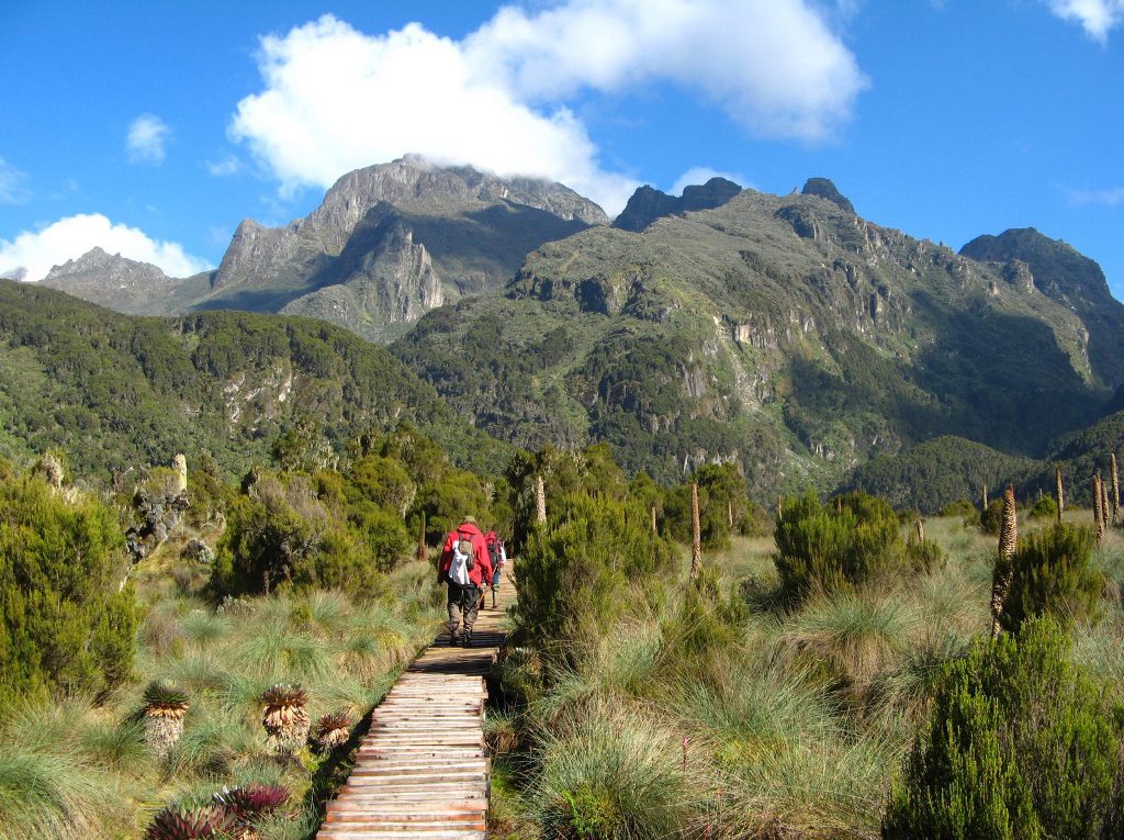
Hiking trips to Mount Emin are more likely on the Congo side than on the Uganda side depending on the season of your visit; the Laba Africa Expeditions is ready to assist you in planning your Rwenzori trip.
WHAT CAUSED THE FORMATION mOUNT EMIN
The mountains were produced roughly three million years ago as a result of an elevated block of crystalline rocks comprising gneiss, amphibolite, granite, and quartzite, as a result of a process known as faulting in the late Pliocene epoch. The Rwenzori Mountains are the highest non-volcanic, non-orogenic mountains in the world.
Which are the other peaks of the Rwenzori Mountains?
As early as 1906, snow and ice covered all six of the Rwenzori’s highest summits. Except for Stanley (5,109 m), Speke (4,890 m), and Baker (4,843 m), all had snow and glaciers in 2001, albeit this is rapidly diminishing.
WHERE IS Mount EMIN LOCATED ?
Mount Emin is situated in the Democratic Republic of Congo and is part of the famous Rwenzori Mountains. It may also be reached from Mugusu Valley, which stretches all the way to DR Congo, by hiking up through the groundswell-covered steep slopes to the pass between the two peaks, then continuing to the top.
Best time HIKE TO mOUNT EMIN
This mountain range is accessible all year, however, it is best walked during the dry months of January, February, June, July, and August due to lower rainfall. In summary, journeys to Mount Emin are always shorter than those to Mount Stanley , Mount Speke, and Mount Baker.
As early as 1906, snow and ice covered all six of the Rwenzori’s highest summits. Except for Stanley (5,109 m), Speke (4,890 m), and Baker (4,843 m), all had snow and glaciers in 2001, albeit this is rapidly diminishing.
Mount Baker
Mount Baker is located in Uganda’s Rwenzori Mountains National Park. It is located 2.8 kilometers from Uganda’s border with the Democratic Republic of the Congo. The peak, known locally as Kiyanja, stands at 4,844 meters (15,892 feet), making it the sixth tallest mountain on the African continent. The trio, along with Mount Speke and Mount Stanley, create a triangle that encircles the upper Bujuku Valley.
Mount Stanley, located 2.26 kilometers (1.40 mi) to the west, is the closest summit. The mountains are located in a region known as “The Mountains of the Moon.” Mount Baker has multiple steep peaks, as do all of the Rwenzori Mountain Range summits, with the highest being Edward Peak.
In January 1906, Austrian climber Rubert Grauer trekked with two British missionaries, H. W. Tegart Addox, and H. E. M, to the height line of Mount Baker. An English excursion team led by A. B. Wosnam, Alexander F. R. Wollaston, and M. Carruthers visited the same rock-strewn location between February and April. Mount Baker’s topmost peak was finally reached in June 1906 by an expedition led by the Duke of Abruzzi. This group trekked to the summits of the Rwenzori’s other five highest mountains.
Franz Stuhlmann noticed the mountain on his trek into the Ruwenzori in June 1891 and called it either Ngemwimbi or Semper. Abruzzi named the peak after Samuel Baker, a British explorer who was the first European to observe and visit Lake Albert, which is located in the northeast of the Rwenzori Mountains, in 1864. Baker also claimed to have seen “huge mountainous masses in the distance, to the south of Lake Albert.”
Mount Speke
Mount Speke is the second-highest mountain in the Rwenzori Mountains National Park and is located within the park. Mount Baker and Mount Stanley form a triangle around the upper Bujuku Valley. Mount Stanley lies 3.55 kilometers (2.21 miles) south-southwest of here. These mountains are found in the Mountains of the Moon area.
These range’s mountains all have multiple jagged tops. Vittorio Emanuele (4,890 meters (16,040 feet), Ensonga (4,865 meters (15,961 feet), Johnston (4,834 meters (15,860 feet), and Trident 4,572 meters are among Mount Speke’s summits (15,000 feet).
Despite the fact that the names were derived from an Italian royal line, they were required to be acknowledged by the government of the British Protectorate of Uganda, which ruled the region at the time.
This mountain was named after John Speke when European explorers first visited the region in quest of the source of the mighty Nile. Despite never visiting this peak, Speke depicted the source of the White Nile in 1862. These regions’ mountains are all named after related explorers who came in Africa during the early days of colonization. Because of the constant rainfall, Mount Speke is penetrated by numerous water streams and rivers, and its vegetation seems dense.
This mountain was named after John Speke when European explorers first visited the region in quest of the source of the mighty Nile. Despite never visiting this peak, Speke depicted the source of the White Nile in 1862. These regions’ mountains are all named after related explorers who came to Africa during the early days of colonization. Because of the constant rainfall, Mount Speke is penetrated by numerous water streams and rivers, and its vegetation seems dense.
Mount Gessi is located near to Mount Emin in the northern part of Mount Stanley, Speke, and Mount Baker. The peak was named after Romulo Gessi, an Italian adventurer. The mountain, which is separated from Emin by a narrow valley in the Rwenzori Mountains National Park, has twin peaks named Lolanda (15,470 ft.) and Bottego (15,470 ft). (15,418 ft.).
Gessi, at 15018 feet (4578 meters), is one of six Rwenzori summits that comprise the Northern Triangle, along with Mount Stanley, Baker, and Speke. Gessi is also Uganda’s fifth tallest mountain, and it is located along a short canyon that continues southward from Mount Emin.
The mountains are also situated on a rocky north-south axis, with the highest peak facing south. On both the DR Congo and Ugandan sides of Mount Gessi, cottages and slope pathways indicate the route. Climbing to Gessi takes a short trail from Mutsori in Congo to its summit, with the majority of the indigenous tribesmen always there to act as porters and guides. Several shanties have been maintained along the Rwenzori.
The hike to Mount Gessi begins in Mugusu Valley and continues through the forests underneath to Roccato Pass, which travels through thick foliage and slabs. It then takes you to the crest that separates the two peaks. It is also believed that the peak was once covered with glaciers that melted. Duke’s ascending route also melted, and it is now a series of highly mossy steep slabs only fit for novices.
Mount Stanley
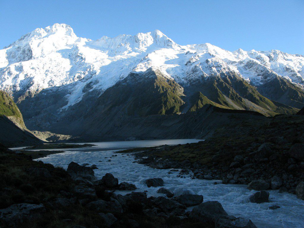
Mount Stanley, with an elevation of 5,109 meters, is located in the Rwenzori Mountains National Park (16,763 ft). It is both Uganda’s and Congo’s highest summit.
The Rwenzori Mountains include Mount Stanley. At a height of 5,109 meters, it is the highest point in the Democratic Republic of the Congo and Uganda (16,763 ft). It is also Africa’s third highest mountain, behind Kilimanjaro (5,895 meters) and Mount Kenya (5,199 meters).
This mountain, like several others nearby, has a height high enough to support glaciers. This mountain is named after the novelist and explorer Sir Henry Morton Stanley. Mount Stanley is part of the UNESCO World Heritage Site Rwenzori Mountains National Park.
Mount Stanley has two twin summits and many minor peaks. The Duke of Abruzzi, J. Petigax, J. Brocherel, and C. Ollier made the first ascent of this mountain on June 18, 1906. Mount Stanley is also a high chain of 11 summits that emerge from glaciers, including the Stanley Plateau, the greatest expanse of ice in the Rwenzori Mountains, measuring over one kilometer in length.
The highest mountain, Margherita, may be accessed by trekking from the Elena hut to the first rocks. The path then passes the Stanley Plateau, which is covered in snow and ice, on its journey to Alexandra Peak, the Massif’s second highest peak.
The standard approach to Margherita Peak passes a steep valley on the summit’s eastern face before ascending the breathtaking Margherita glacier to the saddle between Margherita and Alexandra mountains. From here, head north to a short, steep rock wall that climbs to the summit.
Throughout the ascent, a rope will be required for the heavily crevassed glacier as well as the summit rocks. In addition, the summit acts as a natural boundary between Uganda and the Democratic Republic of the Congo. The eastern narrow peak of Alexandra Peak, at 4990 meters, is likewise a spectacular ascent for any mountain trekker.
Savoia Peak, at 4977 meters, crowns another series of mountains to the south. Climbing any of the aforementioned mountains through the legendary tropical glaciers is an unforgettable experience for the Rwenzori Mountains National Park hikers.
Mount Luigi Di Savoia
Mount Luigi di Savoia is a Rwenzori Mountain in Rwenzori Mountains National Park. Its summit, “Sella,” at 4637 feet, is Uganda’s fourth highest and Africa’s sixth highest. Despite the fact that he called it, Mount Luigi is the only mountain in the Rwenzori range that the Duke of Abruzzi did not attempt to climb.
The Duke of Abruzzi is a well-known climber who made the first ascents of Mt. St. Elias in 1897, as well as trekking high on K2 in the Karakoram and almost reaching Bride Peak on Chogalisa. The Abruzzi Rwenzori excursions included treks to all of the Rwenzori summits.
Mount Luigi Di Savoia is a long ridge with a variety of summits, including Stairs Peak (4545 m.), Sella Peak (4627 m.), and Weismann Peak (4627 m.) (4620 m). The less difficult route is from the Fresh Field Pass region, where the northern face of Sella Peak may be ascended to its summit. It is the shortest of the six central mountains and the first to observe the melting of its glacial ice.
HOW TO GET TO mOUNT EMIN
The trailhead for climbing the Rwenzori Mountains on the Ugandan side, Nyakalengija, is located 22 kilometers from Kasese on the Fort Portal – Kampala Road. You may pay your park fees at the park headquarters in Nyakalengija.
For those who prefer to visit the area without climbing any mountains, the Central Circle Path and the Kilembe Way are excellent options. The Central Circuit Trail will take you roughly eight days to complete
What to pack when climbing Mount Emin?
When planning your hiking trip to Mount Emin either on the Uganda side or Congo side, you will require to pack the following essential items; a day backpack, a pair of binoculars, sunscreen, insect repellent cream, sun glasses, a good pair of mountain hiking boots, socks, gaiters, sleeping bag, toiletries, First aid kit, gloves, energy snacks, trekking poles, hat/cap, insulated jacket, spare batteries, and camera, touch or headlamp to mention but a few.
are you ready to take on Mount EMIN ?
5 Days Rwanda Gorillas and Cultural Safari
10 Days Uganda Gorillas and Rwenzori hike