DISCOVER UGANDA
Mount Gessi- Rwenzori Mountains
Gessi, with a height of 15,018 feet (4578 meters), is one of six Rwenzori mountains in the Northern Triangle, which also includes Mount Stanley, Baker, and Speke.
Mount Gessi is located in the northern portion of Mount Stanley, Speke, and Mount Baker, next to Mount Emin. Its peak was named after an Italian explorer, Romulo Gessi. The mountain is separated from Emin by a short valley in the Rwenzori Mountains National Park and features the twin peaks of Lolanda standing at 15,470 ft and Bottego standing at 15,418 ft. Gessi, with a height of 15,018 feet (4578 meters), is one of six Rwenzori mountains in the Northern Triangle, which also includes Mount Stanley, Baker, and Speke. Gessi is also the fifth highest peak in Uganda, and it is located along a narrow canyon that extends southwards as it splits from Mount Emin.
The mountains are similarly located on a rocky north-south axis, with the top peak pointing south. The Mount Gessi trip is marked by cottages and slope trails on both the Democratic Republic of Congo and Ugandan sides. Trekking to Gessi follows a short path from Mutsori in Congo to its top, with the bulk of the indigenous tribesmen constantly there to work as porters and guides. Throughout the Rwenzori, various shanties have been preserved.
Hiking Mount Gessi, Rwenzori Mountains
Mount Gessi hiking begins in Mugusu Valley and goes through the forest underneath to Roccato pass, which passes through thick vegetation and slabs. It then brings you to the crest between the two summits. It is also thought that the summit was previously covered in glaciers that melted away. Duke’s ascension route melted as well, and it is now a succession of extremely mossy steep slabs that are only suitable for beginners.
Other Peaks in the Rwenzori Mountains
Mount Luigi Di Savoia
Mount Luigi di Savoia is a Rwenzori Mountain in Rwenzori Mountains National Park. Its summit, “Sella,” at 4637 feet, is Uganda’s fourth highest and Africa’s sixth highest. Despite the fact that he called it, Mount Luigi is the only mountain in the Rwenzori range that the Duke of Abruzzi did not attempt to climb. Mount Luigi Di Savoia is a long ridge with multiple peaks, including Stairs Peak (4545 m), Sella Peak (4627 m), and Weismann Peak (4620 m), like the other Rwenzori mountains. The less difficult route is from the Fresh Field Pass region, where the northern face of the Sella top may be ascended to its summit. It is the shortest of the six central mountains and the first to observe the melting of its glacial ice.
The Duke of Abruzzi is a well-known climber, having performed the first ascents of Mt. St. Elias in 1897, as well as trekking high on K2 in the Karakoram and almost reaching the Bride Peak on Chogalisa. The Abruzzi Rwenzori excursions included treks to all of the Rwenzori peaks. He was a military hero who saved many Yugoslav refugees from Albania during World War I, and he spent his final years in Ethiopia, where he was well-liked.
Mount Stanley
The Rwenzori Mountains National Park (16,763 feet) has Mount Stanley (5,109 meters). It is the highest peak in both Uganda and the Democratic Republic of the Congo. The Rwenzori Mountains include Mount Stanley. At 5,109 meters, it is the highest point in the Democratic Republic of the Congo and Uganda (16,763 feet). It is also Africa’s third tallest mountain, after only Mount Kilimanjaro (5,895 meters) and Mount Kenya (5,199 meters). This mountain, like many others in the vicinity, is lofty enough to support glaciers. This mountain is named after the novelist and explorer Sir Henry Morton Stanley. Mount Stanley is part of the UNESCO World Heritage Site Rwenzori Mountains National Park.
Mount Stanley has two twin summits and many minor peaks. The Duke of Abruzzi, J. Petigax, J. Brocherel, and C. Ollier made the first ascent of this mountain on June 18, 1906. Mount Stanley is also a high chain of 11 summits that rise from glaciers, including the Stanley Plateau, the Rwenzori Mountains’ largest stretch of ice at nearly one kilometer in length. The highest mountain, Margherita, may be reached by going from the Elena hut to the first rocks. The route then winds its way through the snow-covered Stanley Plateau to Alexandra summit, the Massif’s second-highest summit.
The most common approach to Margherita Peak ascends through a steep valley on the summit’s eastern face before ascending the beautiful Margherita glacier to the saddle between Margherita and Alexandra peaks. Head north until you reach a small, steep rock wall that leads to the top. During the ascent, a rope will be required for the heavily crevassed glacier as well as the summit rocks. In addition, the summit acts as a natural boundary between Uganda and the Democratic Republic of the Congo. The eastern narrow top of Alexandra top, at 4990 meters, is likewise a lovely addition for any mountain hiker. Savoia Peak, at 4977 meters, leads to another mountain range to the south.
Mount Speke
Mount Speke, nestled inside the Rwenzori Mountains National Park, is the park’s second-highest peak. Mounts Baker and Stanley form a triangle around the upper Bujuku Valley. To the south-southwest, Mount Stanley is 3.55 kilometers (2.21 miles). These mountains are part of the Mountains of the Moon area. This range’s mountains all have jagged peaks. Vittorio Emanuele (4,890 meters (16,040 feet), Ensonga (4,865 meters (15,961 feet), Johnston (4,834 meters (15,860 feet), and Trident 4,572 meters are among Mount Speke’s (15,000-foot) summits.
Despite the fact that the names were derived from an Italian royal line, the British Protectorate of Uganda, which ruled the region at the time, required their acknowledgment. When European explorers first came to the region in quest of the Nile’s source, they named this mountain after John Speke. Despite never having visited this peak, Speke depicted the source of the White Nile in 1862. The mountains in these places are all named after related explorers who arrived in Africa during colonization’s early days. Because of the frequent rains, Mount Speke is penetrated by numerous water streams and rivers, and its vegetation seems dense.
Mount Emin
Mount Emin, located in the Rwenzori Mountains, was named after the central African adventurer Mohamed Emin Pasha. Despite the absence of snow, the challenging peak with narrow and rocky slopes is ranked fourth among the Rwenzori ranges and sixth in Africa. Mount Emin is the second-highest summit in the Democratic Republic of the Congo. It is close to the Ugandan border. It is the third-highest peak in the Democratic Republic of the Congo and part of the six-mountain Ruwenzori range. The mountain was named after Mohammed Emin Pasha, a German doctor who is credited with disseminating scientific and geographical knowledge about Central Africa while doing study in the region. The mountain’s ridges are exceedingly narrow and jagged. Individuals from Zaire and Mutsori live on the mountain’s lower plain and serve as guides.
The mountain has two peaks, Umberto (1574ft) and Kraepelin (15,720ft), both of which are located between the Uganda and Congo borders, making access from the Congo side simpler. Climbing this mountain in the Rwenzori Mountains National Park typically begins from the southwest of the Ridge, which is easily accessible from the Mugusu Valley, which extends into Congo, and then continues through the groundsel sheltered steep descent to the path between both peaks, before continuing to the peak. It is part of the Ruwenzori Mountains National Park, which has been designated a UNESCO World Heritage Site since 1994.
It is located to the north of the triangle formed by the Stanley, Speke, and Baker mountains. In 1906, Luis Amadeo de Saboya was the first Monta Vista to reach the summit of this mountain. He has already ascended the other peaks of the Ruwenzori Mountains. Depending on the season, hiking treks to Mount Emin are more probable on the Congo side than on the Uganda side; Laba Africa Expeditions is ready to assist you in preparing for your Rwenzori adventure.
Mount Baker
Mount Baker lies in Uganda’s Rwenzori Mountains National Park. It is located 2.8 kilometers from Uganda’s border with the Democratic Republic of the Congo. The top, known locally as Kiyanja, is Africa’s sixth-highest mountain, standing at 4,844 meters (15,892 feet). Mount Speke, Mount Stanley, and Mount Stanley form a triangle that encircles the upper Bujuku Valley. Mount Stanley, located 2.26 kilometers (1.40 mi) to the west, is the closest summit. The mountains are located in the region known as “The Mountains of the Moon.” Mount Baker has multiple steep peaks, as do all of the Rwenzori Mountain Range’s summits, the tallest of which is Edward Peak.
Rubert Grauer, an Austrian climber, went to Mount Baker’s height line in January 1906 with two British missionaries, H. W. Tegart Addox and H. E. M. An English excursion party led by A. B. Wosnam, Alexander F. R. Wollaston, and M. Carruthers explored the same rock-strewn region between February and April. An expedition led by the Duke of Abruzzi eventually reached the summit of Mount Baker in June 1906. This group trekked to the summits of the Rwenzori’s last five tallest peaks. In June 1891, on his trip into the Ruwenzori, Franz Stuhlmann noticed the mountain and called it either Ngemwimbi or Semper. Abruzzi named the peak after Samuel Baker, the first European to observe and visit Lake Albert in the Rwenzori Mountains in 1864. Baker saw “huge mountainous masses in the distance, to the south of Lake Albert.”
About the Rwenzori Mountains
The Rwenzori Mountains, also known as the Mountains of the Moon, are located in western Uganda, near the Uganda-Congo border. The tropical snow peaks include Africa’s third highest point, and the lower slopes are covered in moorland, bamboo, and lush, damp montane forest. enormous lobelias and “everlasting flowers” are strewn across the slope with enormous tree heathers and multicolored mosses, creating an exquisite, fairy-tale landscape.
The Rwenzori Mountains stretch for around 120 kilometers and are 65 kilometers wide. Mount Stanley (5,109m), Mount Speke (4,890m), Mount Baker (4,843m), Mount Emin (4,798m), Mount Gessi (4,715m), and Mount Luigi di Savoia (4,627m) are the six peaks. Mount Stanley has numerous minor peaks, the highest of which is Margherita.
What you should know about Rwenzori Mountains National Park
The Rwenzori Mountains National Park in western Uganda contains almost 100,000 acres and is the primary component of the Rwenzori mountain group, which includes Africa’s third-highest peak (Mount Margherita: 5,109 m). The glaciers, waterfalls, and lakes of the region make it one of Africa’s most stunning alpine landscapes. The Rwenzori Mountains National Park, located in southern Uganda, was designated as a UNESCO World Heritage Site in 1994 and a Ramsar site in 2008. The Park also gives excellent possibilities to observe nature at its best. Its plant life ranges from deep tropical rain forests to bamboo woods, montane cloud forests, and high-altitude flora, and the décor is superb. Beyond 4,500 meters, snow and glaciers provide a distinct touch to the breathtaking vistas throughout this pristine mountain range.
The park is home to 70 animals and 217 bird species, including 19 Albertine Rift endemics, as well as some of the world’s most unusual flora. The Rwenzori Mountains are a world-renowned hiking and climbing destination. A nine- to twelve-day walk will take expert climbers to the summit of Margherita, the highest mountain, however, shorter, non-technical climbs to the neighboring summits are conceivable. Nature hikes, farmhouse visits, cultural performances, and lodging, including home-cooked local cuisine, are available in surrounding Bakonzo villages for those looking for something a bit less demanding.
Things to do during your visit to Rwenzori Mountains National Park
The Rwenzori Mountains National Park is one of Uganda’s least visited and unknown destinations. The park is unique in the area because of its stunning beauty.
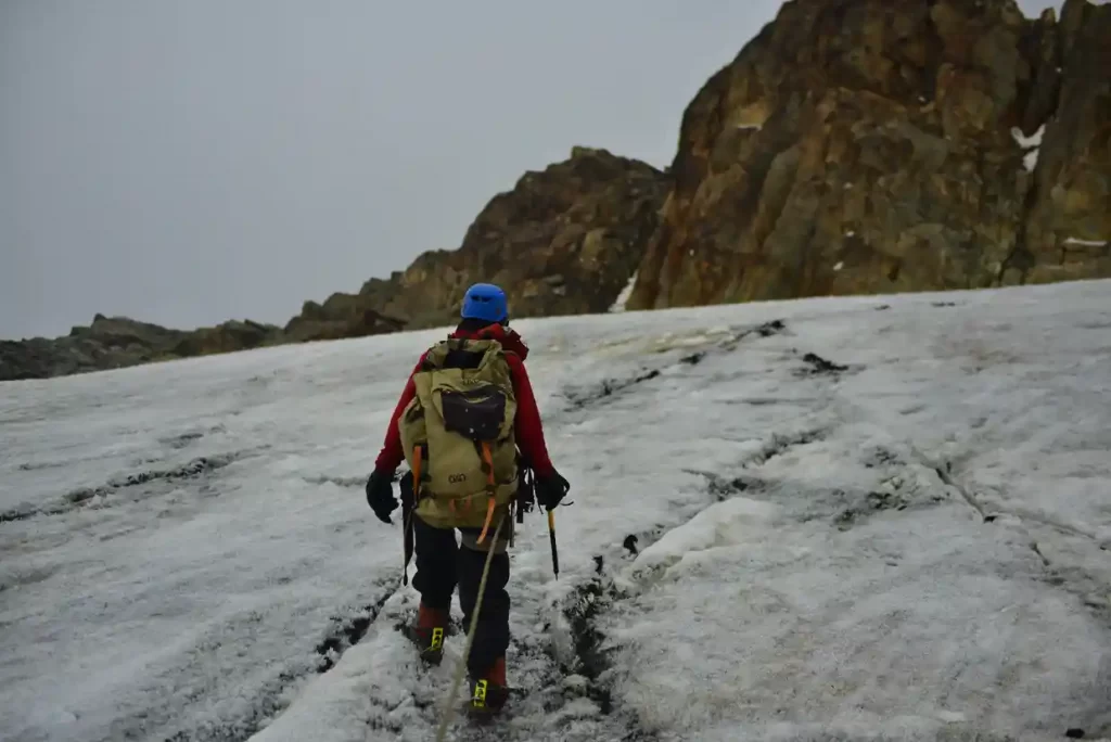
Climbing the Rwenzori Mountains
The Rwenzori Mountains have been ascended by some of the world’s top mountain trekkers. The park’s mountain hiking is organized to world-class standards. Inexperienced hikers may find it difficult to climb the highest summit (Margherita). Shorter and less arduous treks around the mountain can be organized without hiking all the way up to the snow-capped peaks.
Hikers utilize two different hiking trails to reach the peak. The first is the Central Circuit Trail, which begins at Mihunga and lasts seven days. The only organization that arranges hiking along this route is Rwenzori Mountaineering Services. The Kilembe path, which begins in Kilembe near Kasese town, is the second trial. The Rwenzori hiking services operate this new route, which was newly established. One of the summits takes 5 days to reach.
A minimum of nine days is required to explore the three highest peaks. Climbing to the highest summit, Margherita provides views of snow-capped peaks and alpine greenery. Hikers who descend the mountain will be rewarded with more sustained views of the wide farmlands, Queen Elizabeth National Park, and the Virunga hills in the Democratic Republic of the Congo. Climbers will also come across stunning lakes and rivers high in the Alps.
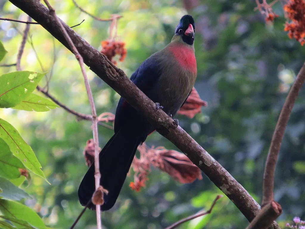
Birding
The Rwenzori Mountains have been designated as a World Heritage Site by UNESCO. The park and its mountains support several species including the African Long-eared Owl, Archers’ Robin-chat, Barbets, Barred Long-tailed Cuckoo, Blue-headed Sunbird, Cinnamon-chested Bee-eater, Collared Apalises, Crimson wings, Dusky and Shelley’s Crimson wings, Dwarf Honeyguide, Evergreen Forest and Bamboo Warblers, Flycatchers, Golden-winged sunbirds, and the Scarlet-tufted Malachite Sunbirds among others.
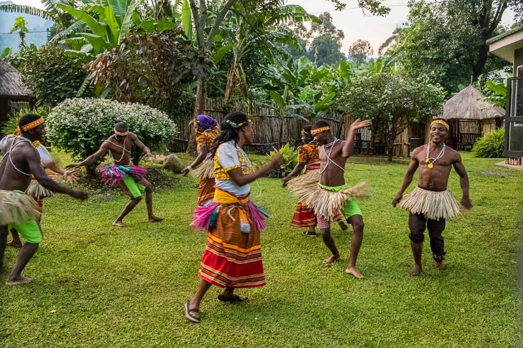
Community Cultural Tours
Cultural interactions with one of the native tribes living at the foot of the Rwenzori Mountains National Park are available. Tourists can visit the village of Ruboni to learn about the Bakonzo tribe’s everyday life and history. The Bakonzo people organize cultural dance events while conveying their history.
The Bulemba-Ihandiro Cultural Trail is another wonderful cultural experience. This route exposes visitors to Bakonzo’s fascinating culture. There are options to see traditional healers and blacksmiths in the area. Visitors learn how to build fire and weave baskets locally. The Bakonzo Traditional Museum is also accessible through the Bulemba-Ihandiro Cultural Trail. The local museum houses a variety of Bakonzo (Rwenzururu) cultural and historical artifacts, such as artworks and locally manufactured garments.
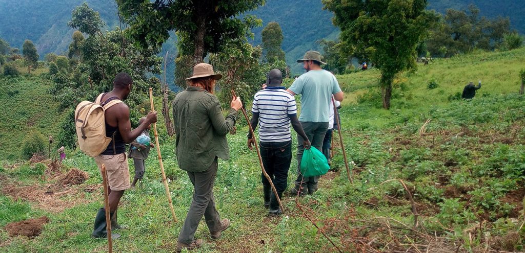
Guided Nature Walks
Nature hikes near the park’s limits may be organized by firms such as Rwenzori Mountain Services (RMS) and Backpackers in Kilembe. RMS-organized walks often follow the primary circuit zone utilized for mountain climbing. The region surrounding the starting site for mountain trekking is wooded and scenic, leading up to Lake Mahoma and the Buraro monkey forest. Other locations to visit when in nature.
How to get to Rwenzori Mountains National Park
Visitors can reach the Rwenzori Mountains National Park by either road or air.
By Road
When traveling by car to the park, there are two options: from Kampala via Mubende to Fort Portal, which is around 300 kilometers and takes about 4 hours to drive. The second route is from Kampala to Kasese through Masaka-Mbarara-Bushenyi and Kasese, which is around 350 kilometers long and takes about 6 hours. This route is perhaps more thrilling because it travels through Lake Mburo National Park to the magnificent Queen Elizabeth National Park; nonetheless, it is lengthy, therefore travelers are advised to stop along the way.
By Air
A chartered flight may be hired, and it only takes 30 minutes to arrive at the Kasese airstrip, from where visitors can travel a short distance to the park.
