DISCOVER UGANDA
Margherita Peak in the Rwenzori Mountains
Margherita Peak, located on Mount Stanley in the Rwenzori Mountains, is the third highest point in Africa, stretching from the center of Lake Albert to the north and Lake Edward to the south on the Congo-Uganda border.
The Rwenzori Mountains are one of the most thrilling mountains ranges to climb. The sheer variety of sceneries, vegetation, and walking trails takes your breath away. The Margherita Peak is the crown gem, and it’s easy to forget you’re in Africa while you’re clutching to your ice axe and rope going up 60% grades surrounded by icicles and snow. Margherita Peak, located on Mount Stanley in the Rwenzori Mountains, is the third highest point in Africa, stretching from the center of Lake Albert to the north and Lake Edward to the south on the Congo-Uganda border. This mountain, which can be reached in 6 to 8 days, is Africa’s third tallest, behind Mount Kilimanjaro and Mount Kenya.
Rwenzori Mountains’ Margherita Peak was named after Queen Margherita of Italy and was first climbed by an expedition led by Luigi Amedeo Abruzzi in 1906, together with the Duke of Abruzzi, J. Petigax, C. Ollier, and J. Brocherel. The Margherita peak in the Rwenzori Mountains is the predecessor of the high-altitude Rwenzori loop, which begins in the dense forests at the edge before ascending well above the clouds to the glacier top of Margherita.
Set beyond Africa’s massive ice cover, the climb continues up, beyond the Margherita Glacier, to the rock scramble to Mount Stanley top, Africa’s third highest mountain in the Rwenzori ranges and hence Uganda’s highest peak. The popular route that runs through Elena Hut is the same one that the pioneers used many years ago. The glaciers in the Rwenzori mountains are fast recoiling as a result of progressive ice melting caused by global warming over the previous decades, making them worth viewing.
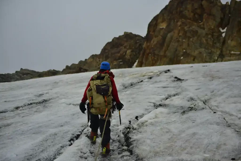
Climbing Margherita Peak in the Rwenzori Mountains
The Rwenzori Mountains hiking trails are essentially classified into two categories: high-altitude and low-altitude. Low-altitude hikes generally last 3-4 days and reach a maximum elevation of roughly 3,100 meters. The high-altitude hikes last 5 to 12 days and reach peak elevations of 4,600 meters or more. If you climb Margherita Peak, you will be in the mountains for at least 7 days and will reach a height of 5,109 meters. The rise will lead you via Elena Hut, past the outhouse, and to a fork in the road. This climb may be approached from the Moraine Hut in the Democratic Republic of the Congo (DRC), however due to political instability in the region, this route is frequently blocked at short notice.
Several paths to the Stanley Plateau may be taken from this junction. Climbing directly up fissures and crevasses, moving west through a line of steep rocks to more moderate slopes above, is one possibility. A second route is to continue south from the little pond into the sheer cliffs of Kitasamba and the Coronation Glacier, reaching a sudden west turn that climbs up slabs toward the Rwenzoris glaciers. Climb steep snow or ice to reach more moderate slopes beyond, onto the Stanley Plateau, which is just northwest of this trail. The weather limits views from the top, with the majority of what is northwest of the Stanley Plateau shrouded in heavy layers of fog. If you do catch a view of the peaks ahead of you, Alexandra Peak is the one on the left. The splendor of the Afro-Montane forest lies below, punctuated by an ever-flowing cascade thundering over the rocks far below.
How to prepare for your climb to Margherita Peak in the Rwenzori Mountains?
To reach the summit of Margherita Peak, you must navigate ice passages, rocks, and steep inclines with 60% slopes. It’s typically regarded as more difficult than Kilimanjaro, so you should be in good shape and have some experience climbing at high altitudes. The hike to Margherita Peak was recently designated as a tough climb, however, this only applies to the last day when you reach the peak. You will be escorted by a professional climbing crew, and all equipment (except crampons, which you must carry with you) will be given.
Group Size
We provide both group and individual hikes. You may select any day, and the number of other individuals in the group will simply be determined by how many other people have planned to be in the mountains on that date. If no one else has reserved your dates, the journey will be conducted as a private tour. The maximum group size for high-altitude hikes is 8 or 9, while for low-altitude treks, it can be up to 15.
Hiring Hiking Gear
The Rwenzoris have very high standards for both equipment and training. The staff is also continuously in the mountains, looking for new routes and maintaining old ones so that even when tourist numbers are low, the routes do not get stale. We collaborate with the top area professionals who place high importance on safety. To keep the local guides up to speed on alpine methods and safety, external trainers are brought in. All of the technical equipment, including ropes, ice screws, ice axes, harnesses, and crampons, is imported from the United Kingdom. We prefer that each customer bring their own crampons, however, there are some available for rent.
Harnesses, caribinas, ice axes, helmets, rubber boots, ropes, and ice screws are given for all excursions to the summit of Margherita Mountain. Technical climbing knowledge is only required on one day while ascending Margherita Peak. When traversing the Stanley Plateau, you will need to wear crampons, ice axes, and other technical equipment. The Margherita glacier ascent begins here. The gradient is roughly 60% and changes quickly; there are numerous difficult rock scrambles before reaching the peak. The summit trek takes around 7-10 hours (there and return to Hunwick’s camp). Although some people might take up to 16 hours if they are not in good shape.
Summiting Margherita needs strong fitness and, preferably, at least one previous attempt at a high-altitude mountain. In summit hikes to Margherita Peak, we have a 98% success rate. While some prior experience is always ideal, the majority of our guests have never used crampons/ice axes before – but our local guides are true pros, and if you’re in excellent shape and motivated, you should have no trouble reaching the Rwenzori’s snowy summits!
Other Peaks in the Rwenzori Mountains
Mount Emin
Mount Emin in the Rwenzori Mountains was named after the central African explorer Mohamed Emin Pasha. Despite the lack of snow, the difficult mountain with narrow and rocky slopes ranks fourth among the Rwenzori ranges and sixth in Africa. Mount Emin is the Democratic Republic of the Congo’s second-highest peak. It is near the Ugandan border. It is the third-highest peak in the Democratic Republic of the Congo and part of the Ruwenzori mountain range, which consists of six peaks. The peak was named after Mohammed Emin Pasha, a German doctor who is recognized for spreading scientific and geographical information about Central Africa while doing research there. The ridges of the mountain are extremely small and craggy. Individuals from Zaire and Mutsori reside on the lower plain of the mountain and work as guides.
The mountain contains two summits, Umberto (1574 feet) and Kraepelin (15,720 feet), which are both located between the Uganda and Congo borders, making access from the Congo side easier. Climbing this mountain in the Rwenzori Mountains National Park usually starts from the southwest of the Ridge, which is easily accessible from the Mugusu Valley, which extends into Congo, and then continues through the groundsel-sheltered steep descent to the path between both peaks, before continuing to the peak. It is part of the Ruwenzori Mountains National Park, a UNESCO World Heritage Site since 1994. It is situated to the north of the triangle created by the mountains of Stanley, Speke, and Baker. It is situated to the north of the triangle created by the mountains of Stanley, Speke, and Baker. Luis Amadeo de Saboya was the first Monta Vista to reach the mountain’s peak in 1906. He has already climbed the Ruwenzori Mountains’ other summits.
Mount Gessi
Mount Gessi is located near to Mount Emin in the northern part of Mount Stanley, Speke, and Mount Baker. Its highest point was named after an Italian adventurer called Romulo Gessi. The mountain is separated from Emin by a small valley in the Rwenzori Mountains National Park and is home to the twin peaks of Lolanda (15,470 feet) and Bottego (15,418 feet). Gessi, at 15,018 feet (4578 meters), is one of six Rwenzori summits that make up the Northern Triangle, along with Mount Stanley, Baker, and Speke. Gessi is also Uganda’s fifth tallest mountain, and it is located along a short canyon that continues southward from Mount Emin.
The mountains are also situated on a rocky north-south axis, with the highest peak facing south. On both the Democratic Republic of the Congo and Ugandan sides of Mount Gessi, huts and slope pathways indicate the route. The trek to Gessi follows a short trail from Mutsori in Congo to its summit, with the majority of the indigenous tribesmen always there to act as porters and guides. Various shanties have been preserved across the Rwenzori.
Mount Stanley
Mount Stanley (5,109 meters) is located in the Rwenzori Mountains National Park (16,763 feet). It is both Uganda’s and the Democratic Republic of the Congo’s tallest summit. Mount Stanley is part of the Rwenzori Mountains. It is the highest peak in the Democratic Republic of the Congo and Uganda (16,763 ft) at 5,109 meters. It is also Africa’s third highest peak, after only Mount Kilimanjaro (5,895 meters) and Mount Kenya (5,199 meters). This peak, like many others in the area, is high enough to sustain glaciers. This mountain is named after Sir Henry Morton Stanley, an author, and adventurer. Mount Stanley is part of the Rwenzori Mountains National Park, a UNESCO World Heritage Site.
Mount Stanley is also a high chain of 11 peaks that rise from glaciers, including the Stanley Plateau, the biggest expanse of ice in the Rwenzori Mountains at about one kilometer in length. Margherita, the highest peak, may be accessed by walking from the Elena cabin to the first rocks. The path then goes across the snow-covered Stanley Plateau to Alexandra Top, the Massif’s second-highest peak. The most typical approach to Margherita Peak is by a steep valley on the summit’s eastern slope, followed by an ascent of the spectacular Margherita glacier to the saddle between the Margherita and Alexandra summits. Continue north until you reach a narrow, high rock wall leading to the top.
A rope will be necessary for the badly crevassed glacier as well as the summit rocks throughout the ascent. The peak also serves as a natural border between Uganda and the Democratic Republic of the Congo. At 4990 meters, the eastern narrow top of Alexandra top is also a great bonus for any mountain walker. At 4977 meters, Savoia Peak links to another mountain range to the south.
Mount Baker
Mount Baker is located in the Rwenzori Mountains National Park in Uganda. It lies 2.8 kilometers from the border of Uganda with the Democratic Republic of the Congo. The peak, known as Kiyanja in local parlance, is Africa’s sixth-highest mountain, reaching at 4,844 meters (15,892 feet). The upper Bujuku Valley is encircled by a triangle formed by Mount Speke, Mount Stanley, and Mount Stanley. Mount Stanley is the nearest summit, located 2.26 kilometers (1.40 mi) to the west. The mountains are in an area known as “The Mountains of the Moon.” Mount Baker features several high peaks, as do all of the summits of the Rwenzori Mountain Range, the largest of which is Edward Peak.
In January 1906, Austrian climber Rubert Grauer traveled to Mount Baker’s summit with two British missionaries, H. W. Tegart Addox and H. E. M. Between February and April, an English excursion team commanded by A. B. Wosnam, Alexander F. R. Wollaston, and M. Carruthers investigated the same rock-strewn terrain. In June 1906, an expedition led by the Duke of Abruzzi reached the summit of Mount Baker. This party hiked to the tops of the Rwenzori’s final five highest peaks. On an expedition into the Ruwenzori in June 1891, Franz Stuhlmann discovered the peak and named it either Ngemwimbi or Semper. Samuel Baker, the first European to notice and visit Lake Albert in the Rwenzori Mountains in 1864, inspired Abruzzi to name the summit after him.
Mount Speke
Mount Speke is the park’s second-highest mountain, located inside the Rwenzori Mountains National Park. Mount Baker and Mount Stanley create a triangle that encircles the upper Bujuku Valley. Mount Stanley lies 3.55 kilometers (2.21 miles) to the south-southwest. These mountains are located in the Mountains of the Moon region. The mountains in this range all have craggy summits. Mount Speke’s (15,000-foot) peaks include Vittorio Emanuele (4,890 meters (16,040 feet), Ensonga (4,865 meters (15,961 feet), Johnston (4,834 meters (15,860 feet), and Trident 4,572 meters.
Despite the fact that the names came from an Italian royal line, the British Protectorate of Uganda, which administered the region at the time, demanded that they be acknowledged. When European explorers first arrived in the area in search of the Nile’s source, they dubbed this peak John Speke. Despite never having visited this summit, Speke portrayed the White Nile’s source in 1862. The mountains in these locations are all named after related explorers who came in Africa during the early days of colonization. Mount Speke is pierced by numerous water streams and rivers as a result of the regular rains, and its flora appears thick.
Mount Luigi Di Savoia
Mount Luigi di Savoia is a Rwenzori Mountain located inside the Rwenzori Mountains National Park. At 4637 feet, its summit, “Sella,” is Uganda’s fourth highest and Africa’s sixth highest. Mount Luigi, despite its name, is the only mountain in the Rwenzori range that the Duke of Abruzzi did not attempt to climb. Mount Luigi Di Savoia, like the other Rwenzori mountains, has a long ridge with many summits, including Stairs Peak (4545 m), Sella Peak (4627 m), and Weismann Peak (4620 m). The easier method is to scale the northern face of the Sella Peak to its summit from the Fresh Field Pass area.
In Summary; The Rwenzori Mountains are one of the most thrilling mountains ranges to climb. The sheer variety of sceneries, vegetation, and walking trails takes your breath away. The Margherita Peak is the crown gem, and it’s easy to forget you’re in Africa while you’re clutching to your ice axe and rope going up 60% grades surrounded by icicles and snow.
